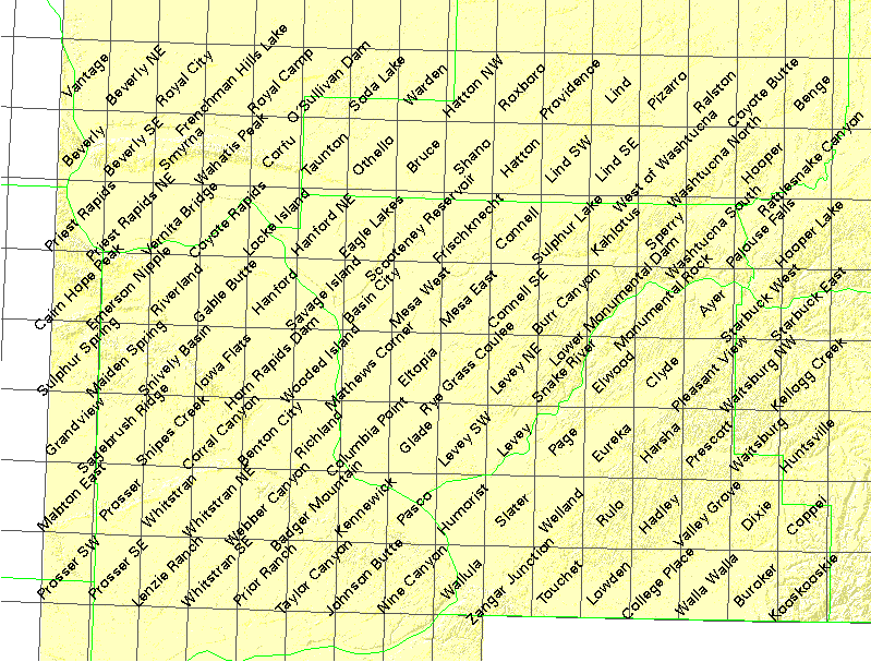
The table below is ordered by the WADNR numbering scheme, .i.e. by row and column. Each 7.5' quad has a unique ID number. The first two digits of the ID number count down from 49 degress. The last two digits count east from 125 degrees. Leading zeros are omitted so that quads above 47.875 degrees are three digits. and sliver quads above 49 degrees are two digits.
There may be one or more images for each quads, and one
or more images for each quarter quad.
USGS quarter quads from BIL files are colored linen,
USGS quarter quads from TIFF files are colored moccasin,
Replacement quarter quads (mostly) from TIFF files
are colored blanchedalmond
(Caution these are NAD27),
USFS full quads at 1-meter pixel size are colored green, and
USFS full quads at 2-meter pixel size are colored blue..
If you want to search by quad name, lower-left corner, or USGS numbering
scheme, use the find button of your web browser. Data west of
120░ (last two digits of DNR code less than 41, or USGS code digits 3-5 greater
than 119) are in Universal Transverse Mercator (UTM) zone 10.
Data east of 120░ are in UTM zone 11, a completely different coordinate system.
All but the replacement files are NAD83. The bundled README files explain datums.
Click on the "zipfile" link to download the image with metadata and alternate tfw files, or click on the metadata link for a text description. File sizes (rounded to the nearest million bytes) are shown for the uncompressed image file and for the downloadable zip file. Quarter quads and 2-meter full quads are about 35 megabytes, and full 1-meter quads are about 140 megabytes. Most data is available on cdrom (mostly in bil format) at the University of Washington Library Map Collection.
Some of this data may be browsed at Microsoft's online viewer
Some fine day, these will all be converted to proper geotiff format.
| quadrant/quad | DNR# | image date | lower left | CDROM | CDROM file | download file | image fsize | zipfile | meta data |
|---|---|---|---|---|---|---|---|---|---|
| NE Vantage | 1741 | 1996-07-12 | 46░56'15" -119░56'15" | 625_2 | o4611901_nes | 46119h8_ne_1996.tif | 44M | 35M | text |
| NW Vantage | 1741 | 1996-07-12 | 46░56'15" -120░0'0" | 625_2 | o4611901_nws | 46119h8_nw_1996.tif | 44M | 36M | text |
| SE Vantage | 1741 | 1996-07-12 | 46░52'30" -119░56'15" | 625_2 | o4611901_ses | 46119h8_se_1996.tif | 44M | 36M | text |
| SW Vantage | 1741 | 1996-07-12 | 46░52'30" -120░0'0" | 649_1 | o4611901_sws | 46119h8_sw_1996.tif | 44M | 36M | text |
| quadrant/quad | DNR# | image date | lower left | CDROM | CDROM file | download file | Mbytes | zipfile | meta |
| NE Beverly NE | 1742 | 1996-07-10 | 46░56'15" -119░48'45" | 49_2 | o4611902_nes | 46119h7_ne_1996.tif | 44M | 37M | text |
| NW Beverly NE | 1742 | 1996-07-12 | 46░56'15" -119░52'30" | 49_2 | o4611902_nws | 46119h7_nw_1996.tif | 44M | 39M | text |
| SE Beverly NE | 1742 | 1996-07-10 | 46░52'30" -119░48'45" | 49_2 | o4611902_ses | 46119h7_se_1996.tif | 44M | 37M | text |
| SW Beverly NE | 1742 | 1996-07-12 | 46░52'30" -119░52'30" | 49_2 | o4611902_sws | 46119h7_sw_1996.tif | 44M | 39M | text |
| quadrant/quad | DNR# | image date | lower left | CDROM | CDROM file | download file | Mbytes | zipfile | meta |
| NE Royal City | 1743 | 1996-07-10 | 46░56'15" -119░41'15" | 49_2 | o4611903_nes | 46119h6_ne_1996.tif | 44M | 36M | text |
| NW Royal City | 1743 | 1996-07-10 | 46░56'15" -119░45'0" | 49_2 | o4611903_nws | 46119h6_nw_1996.tif | 44M | 37M | text |
| SE Royal City | 1743 | 1996-07-10 | 46░52'30" -119░41'15" | 49_2 | o4611903_ses | 46119h6_se_1996.tif | 44M | 37M | text |
| SW Royal City | 1743 | 1996-07-10 | 46░52'30" -119░45'0" | 49_2 | o4611903_sws | 46119h6_sw_1996.tif | 44M | 38M | text |
| quadrant/quad | DNR# | image date | lower left | CDROM | CDROM file | download file | Mbytes | zipfile | meta |
| NE Frenchman Hills Lake | 1744 | 1996-07-13 | 46░56'15" -119░33'45" | 49_2 | o4611904_nes | 46119h5_ne_1996.tif | 44M | 37M | text |
| NW Frenchman Hills Lake | 1744 | 1996-07-13 | 46░56'15" -119░37'30" | 49_2 | o4611904_nws | 46119h5_nw_1996.tif | 44M | 37M | text |
| SE Frenchman Hills Lake | 1744 | 1996-07-13 | 46░52'30" -119░33'45" | 73_1 | o4611904_ses | 46119h5_se_1996.tif | 44M | 38M | text |
| SW Frenchman Hills Lake | 1744 | 1996-07-13 | 46░52'30" -119░37'30" | 73_1 | o4611904_sws | 46119h5_sw_1996.tif | 44M | 37M | text |
| quadrant/quad | DNR# | image date | lower left | CDROM | CDROM file | download file | Mbytes | zipfile | meta |
| NE Royal Camp | 1745 | 1996-07-08 | 46░56'15" -119░26'15" | 1416_1 | o4611905_nes | 46119h4_ne_1996.tif | 44M | 36M | text |
| NW Royal Camp | 1745 | 1996-07-12 | 46░56'15" -119░30'0" | 1416_1 | o4611905_nws | 46119h4_nw_1996.tif | 44M | 37M | text |
| SE Royal Camp | 1745 | 1996-07-08 | 46░52'30" -119░26'15" | 1416_1 | o4611905_ses | 46119h4_se_1996.tif | 44M | 37M | text |
| SW Royal Camp | 1745 | 1996-07-12 | 46░52'30" -119░30'0" | 1416_1 | o4611905_sws | 46119h4_sw_1996.tif | 44M | 37M | text |
| quadrant/quad | DNR# | image date | lower left | CDROM | CDROM file | download file | Mbytes | zipfile | meta |
| NE O'Sullivan Dam | 1746 | 1996-07-08 | 46░56'15" -119░18'45" | 1416_1 | o4611906_nes | 46119h3_ne_1996.tif | 43M | 36M | text |
| NW O'Sullivan Dam | 1746 | 1996-07-13 | 46░56'15" -119░22'30" | 1416_1 | o4611906_nws | 46119h3_nw_1996.tif | 44M | 36M | text |
| SE O'Sullivan Dam | 1746 | 1996-07-08 | 46░52'30" -119░18'45" | 1416_1 | o4611906_ses | 46119h3_se_1996.tif | 43M | 35M | text |
| SW O'Sullivan Dam | 1746 | 1996-07-13 | 46░52'30" -119░22'30" | 1416_1 | o4611906_sws | 46119h3_sw_1996.tif | 44M | 37M | text |
| quadrant/quad | DNR# | image date | lower left | CDROM | CDROM file | download file | Mbytes | zipfile | meta |
| NE Soda Lake | 1747 | 1996-07-08 | 46░56'15" -119░11'15" | 313_1 | o4611907_nes | 46119h2_ne_1996.tif | 43M | 35M | text |
| NW Soda Lake | 1747 | 1996-07-05 | 46░56'15" -119░15'0" | 313_1 | o4611907_nws | 46119h2_nw_1996.tif | 43M | 35M | text |
| SE Soda Lake | 1747 | 1996-07-08 | 46░52'30" -119░11'15" | 313_1 | o4611907_ses | 46119h2_se_1996.tif | 43M | 36M | text |
| SW Soda Lake | 1747 | 1996-07-05 | 46░52'30" -119░15'0" | 313_1 | o4611907_sws | 46119h2_sw_1996.tif | 43M | 35M | text |
| quadrant/quad | DNR# | image date | lower left | CDROM | CDROM file | download file | Mbytes | zipfile | meta |
| NE Warden | 1748 | 1996-07-05 | 46░56'15" -119░3'45" | 313_1 | o4611908_nes | 46119h1_ne_1996.tif | 43M | 35M | text |
| NW Warden | 1748 | 1996-07-05 | 46░56'15" -119░7'30" | 313_1 | o4611908_nws | 46119h1_nw_1996.tif | 43M | 35M | text |
| SE Warden | 1748 | 1996-07-05 | 46░52'30" -119░3'45" | 313_1 | o4611908_ses | 46119h1_se_1996.tif | 43M | 33M | text |
| SW Warden | 1748 | 1996-07-05 | 46░52'30" -119░7'30" | 313_1 | o4611908_sws | 46119h1_sw_1996.tif | 43M | 35M | text |
| quadrant/quad | DNR# | image date | lower left | CDROM | CDROM file | download file | Mbytes | zipfile | meta |
| NE Hatton NW | 1749 | 1996-07-01 | 46░56'15" -118░56'15" | 289_2 | o4611801_nes | 46118h8_ne_1996.tif | 43M | 33M | text |
| NW Hatton NW | 1749 | 1996-07-13 | 46░56'15" -119░0'0" | 289_2 | o4611801_nws | 46118h8_nw_1996.tif | 43M | 36M | text |
| SE Hatton NW | 1749 | 1996-07-01 | 46░52'30" -118░56'15" | 313_1 | o4611801_ses | 46118h8_se_1996.tif | 43M | 34M | text |
| SW Hatton NW | 1749 | 1996-07-13 | 46░52'30" -119░0'0" | 313_1 | o4611801_sws | 46118h8_sw_1996.tif | 43M | 34M | text |
| quadrant/quad | DNR# | image date | lower left | CDROM | CDROM file | download file | Mbytes | zipfile | meta |
| NE Roxboro | 1750 | 1996-07-01 | 46░56'15" -118░48'45" | 313_1 | o4611802_nes | 46118h7_ne_1996.tif | 43M | 33M | text |
| NW Roxboro | 1750 | 1996-07-01 | 46░56'15" -118░52'30" | 313_1 | o4611802_nws | 46118h7_nw_1996.tif | 43M | 33M | text |
| SE Roxboro | 1750 | 1996-07-01 | 46░52'30" -118░48'45" | 313_2 | o4611802_ses | 46118h7_se_1996.tif | 43M | 33M | text |
| SW Roxboro | 1750 | 1996-07-01 | 46░52'30" -118░52'30" | 313_2 | o4611802_sws | 46118h7_sw_1996.tif | 43M | 33M | text |
| quadrant/quad | DNR# | image date | lower left | CDROM | CDROM file | download file | Mbytes | zipfile | meta |
| NE Providence | 1751 | 1996-07-05 | 46░56'15" -118░41'15" | 313_2 | o4611803_nes | 46118h6_ne_1996.tif | 43M | 34M | text |
| NW Providence | 1751 | 1996-07-05 | 46░56'15" -118░45'0" | 313_2 | o4611803_nws | 46118h6_nw_1996.tif | 43M | 36M | text |
| SE Providence | 1751 | 1996-07-05 | 46░52'30" -118░41'15" | 313_2 | o4611803_ses | 46118h6_se_1996.tif | 43M | 34M | text |
| SW Providence | 1751 | 1996-07-05 | 46░52'30" -118░45'0" | 313_2 | o4611803_sws | 46118h6_sw_1996.tif | 43M | 35M | text |
| quadrant/quad | DNR# | image date | lower left | CDROM | CDROM file | download file | Mbytes | zipfile | meta |
| NE Lind | 1752 | 1996-07-01 | 46░56'15" -118░33'45" | 313_2 | o4611804_nes | 46118h5_ne_1996.tif | 43M | 34M | text |
| NW Lind | 1752 | 1996-07-05 | 46░56'15" -118░37'30" | 313_2 | o4611804_nws | 46118h5_nw_1996.tif | 43M | 35M | text |
| SE Lind | 1752 | 1996-07-01 | 46░52'30" -118░33'45" | 313_2 | o4611804_ses | 46118h5_se_1996.tif | 43M | 33M | text |
| SW Lind | 1752 | 1996-07-05 | 46░52'30" -118░37'30" | 313_2 | o4611804_sws | 46118h5_sw_1996.tif | 43M | 34M | text |
| quadrant/quad | DNR# | image date | lower left | CDROM | CDROM file | download file | Mbytes | zipfile | meta |
| NE Pizarro | 1753 | 1996-07-01 | 46░56'15" -118░26'15" | G4281.A4_s40_.G4_2_2004 | 46118h42.tif | 46118h4_ne_1996.tif | 43M | 34M | text |
| NW Pizarro | 1753 | 1996-07-01 | 46░56'15" -118░30'0" | G4281.A4_s40_.G4_2_2004 | 46118h41.tif | 46118h4_nw_1996.tif | 43M | 33M | text |
| SE Pizarro | 1753 | 1996-07-01 | 46░52'30" -118░26'15" | G4281.A4_s40_.G4_2_2004 | 46118h43.tif | 46118h4_se_1996.tif | 43M | 33M | text |
| SW Pizarro | 1753 | 1996-07-01 | 46░52'30" -118░30'0" | G4281.A4_s40_.G4_2_2004 | 46118h44.tif | 46118h4_sw_1996.tif | 43M | 34M | text |
| quadrant/quad | DNR# | image date | lower left | CDROM | CDROM file | download file | Mbytes | zipfile | meta |
| NE Ralston | 1754 | 1996-07-01 | 46░56'15" -118░18'45" | G4281.A4_s40_.G4_1_2004 | 46118h32.tif | 46118h3_ne_1996.tif | 42M | 32M | text |
| NW Ralston | 1754 | 1996-07-01 | 46░56'15" -118░22'30" | G4281.A4_s40_.G4_1_2004 | 46118h31.tif | 46118h3_nw_1996.tif | 43M | 33M | text |
| SE Ralston | 1754 | 1996-07-01 | 46░52'30" -118░18'45" | G4281.A4_s40_.G4_2_2004 | 46118h33.tif | 46118h3_se_1996.tif | 42M | 32M | text |
| SW Ralston | 1754 | 1996-07-01 | 46░52'30" -118░22'30" | G4281.A4_s40_.G4_2_2004 | 46118h34.tif | 46118h3_sw_1996.tif | 43M | 33M | text |
| quadrant/quad | DNR# | image date | lower left | CDROM | CDROM file | download file | Mbytes | zipfile | meta |
| NE Coyote Butte | 1755 | 1996-07-05 | 46░56'15" -118░11'15" | G4281.A4_s40_.G4_1_2004 | 46118h22.tif | 46118h2_ne_1996.tif | 42M | 33M | text |
| NW Coyote Butte | 1755 | 1996-07-05 | 46░56'15" -118░15'0" | G4281.A4_s40_.G4_1_2004 | 46118h21.tif | 46118h2_nw_1996.tif | 42M | 32M | text |
| SE Coyote Butte | 1755 | 1996-07-05 | 46░52'30" -118░11'15" | G4281.A4_s40_.G4_1_2004 | 46118h23.tif | 46118h2_se_1996.tif | 42M | 33M | text |
| SW Coyote Butte | 1755 | 1996-07-05 | 46░52'30" -118░15'0" | G4281.A4_s40_.G4_1_2004 | 46118h24.tif | 46118h2_sw_1996.tif | 42M | 32M | text |
| quadrant/quad | DNR# | image date | lower left | CDROM | CDROM file | download file | Mbytes | zipfile | meta |
| NE Benge | 1756 | 1996-07-05 | 46░56'15" -118░3'45" | G4281.A4_s40_.G4_1_2004 | 46118h12.tif | 46118h1_ne_1996.tif | 42M | 35M | text |
| NW Benge | 1756 | 1996-07-05 | 46░56'15" -118░7'30" | G4281.A4_s40_.G4_1_2004 | 46118h11.tif | 46118h1_nw_1996.tif | 42M | 34M | text |
| SE Benge | 1756 | 1996-07-05 | 46░52'30" -118░3'45" | 193_1 | o4611808_ses | 46118h1_se_1996.tif | 42M | 36M | text |
| SW Benge | 1756 | 1996-07-05 | 46░52'30" -118░7'30" | 193_1 | o4611808_sws | 46118h1_sw_1996.tif | 42M | 34M | text |
| quadrant/quad | DNR# | image date | lower left | CDROM | CDROM file | download file | Mbytes | zipfile | meta |
| NE Beverly | 1841 | 2000-06-03 | 46░48'45" -119░56'15" | 49_1_2001 | 46119g82.tif | 46119g8_ne_2000.tif | 44M | 37M | text |
| NW Beverly | 1841 | 2000-06-03 | 46░48'45" -120░0'0" | 49_1_2001 | 46119g81.tif | 46119g8_nw_2000.tif | 44M | 39M | text |
| SE Beverly | 1841 | 2000-06-03 | 46░45'0" -119░56'15" | 49_1_2001 | 46119g83.tif | 46119g8_se_2000.tif | 44M | 38M | text |
| SW Beverly | 1841 | 2000-06-03 | 46░45'0" -120░0'0" | 49_1_2001 | 46119g84.tif | 46119g8_sw_2000.tif | 44M | 36M | text |
| quadrant/quad | DNR# | image date | lower left | CDROM | CDROM file | download file | Mbytes | zipfile | meta |
| NE Beverly SE | 1842 | 1996-07-10 | 46░48'45" -119░48'45" | 49_1 | o4611910_nes | 46119g7_ne_1996.tif | 44M | 35M | text |
| NW Beverly SE | 1842 | 1996-07-12 | 46░48'45" -119░52'30" | 49_1 | o4611910_nws | 46119g7_nw_1996.tif | 44M | 37M | text |
| SE Beverly SE | 1842 | 1996-07-10 | 46░45'0" -119░48'45" | 49_1 | o4611910_ses | 46119g7_se_1996.tif | 44M | 34M | text |
| SW Beverly SE | 1842 | 1996-07-12 | 46░45'0" -119░52'30" | 49_1 | o4611910_sws | 46119g7_sw_1996.tif | 44M | 37M | text |
| quadrant/quad | DNR# | image date | lower left | CDROM | CDROM file | download file | Mbytes | zipfile | meta |
| NE Smyrna | 1843 | 1996-07-10 | 46░48'45" -119░41'15" | 49_1 | o4611911_nes | 46119g6_ne_1996.tif | 44M | 35M | text |
| NW Smyrna | 1843 | 1996-07-10 | 46░48'45" -119░45'0" | 49_1 | o4611911_nws | 46119g6_nw_1996.tif | 44M | 36M | text |
| SE Smyrna | 1843 | 1996-07-10 | 46░45'0" -119░41'15" | 49_1 | o4611911_ses | 46119g6_se_1996.tif | 44M | 36M | text |
| SW Smyrna | 1843 | 1996-07-10 | 46░45'0" -119░45'0" | 49_1 | o4611911_sws | 46119g6_sw_1996.tif | 44M | 35M | text |
| quadrant/quad | DNR# | image date | lower left | CDROM | CDROM file | download file | Mbytes | zipfile | meta |
| NE Wahatis Peak | 1844 | 1996-07-13 | 46░48'45" -119░33'45" | 49_1 | o4611912_nes | 46119g5_ne_1996.tif | 44M | 36M | text |
| NW Wahatis Peak | 1844 | 1996-07-13 | 46░48'45" -119░37'30" | 49_1 | o4611912_nws | 46119g5_nw_1996.tif | 44M | 36M | text |
| SE Wahatis Peak | 1844 | 1996-07-13 | 46░45'0" -119░33'45" | 49_2 | o4611912_ses | 46119g5_se_1996.tif | 44M | 34M | text |
| SW Wahatis Peak | 1844 | 1996-07-13 | 46░45'0" -119░37'30" | 49_2 | o4611912_sws | 46119g5_sw_1996.tif | 44M | 35M | text |
| quadrant/quad | DNR# | image date | lower left | CDROM | CDROM file | download file | Mbytes | zipfile | meta |
| NE Corfu | 1845 | 1996-07-08 | 46░48'45" -119░26'15" | 73_1 | o4611913_nes | 46119g4_ne_1996.tif | 44M | 36M | text |
| NW Corfu | 1845 | 1996-07-12 | 46░48'45" -119░30'0" | 73_1 | o4611913_nws | 46119g4_nw_1996.tif | 44M | 37M | text |
| SE Corfu | 1845 | 1996-07-08 | 46░45'0" -119░26'15" | 73_1 | o4611913_ses | 46119g4_se_1996.tif | 44M | 33M | text |
| SW Corfu | 1845 | 1996-07-12 | 46░45'0" -119░30'0" | 73_1 | o4611913_sws | 46119g4_sw_1996.tif | 44M | 33M | text |
| quadrant/quad | DNR# | image date | lower left | CDROM | CDROM file | download file | Mbytes | zipfile | meta |
| NE Taunton | 1846 | 1996-07-08 | 46░48'45" -119░18'45" | 73_1 | o4611914_nes | 46119g3_ne_1996.tif | 44M | 34M | text |
| NW Taunton | 1846 | 1996-07-05 | 46░48'45" -119░22'30" | 73_1 | o4611914_nws | 46119g3_nw_1996.tif | 44M | 35M | text |
| SE Taunton | 1846 | 1996-07-08 | 46░45'0" -119░18'45" | 73_1 | o4611914_ses | 46119g3_se_1996.tif | 44M | 36M | text |
| SW Taunton | 1846 | 1996-07-05 | 46░45'0" -119░22'30" | 73_1 | o4611914_sws | 46119g3_sw_1996.tif | 44M | 34M | text |
| quadrant/quad | DNR# | image date | lower left | CDROM | CDROM file | download file | Mbytes | zipfile | meta |
| NE Othello | 1847 | 1996-07-08 | 46░48'45" -119░11'15" | 337_1 | o4611915_nes | 46119g2_ne_1996.tif | 43M | 37M | text |
| NW Othello | 1847 | 1996-07-05 | 46░48'45" -119░15'0" | 337_1 | o4611915_nws | 46119g2_nw_1996.tif | 43M | 35M | text |
| SE Othello | 1847 | 1996-07-08 | 46░45'0" -119░11'15" | 337_1 | o4611915_ses | 46119g2_se_1996.tif | 43M | 37M | text |
| SW Othello | 1847 | 1996-07-05 | 46░45'0" -119░15'0" | 337_1 | o4611915_sws | 46119g2_sw_1996.tif | 44M | 37M | text |
| quadrant/quad | DNR# | image date | lower left | CDROM | CDROM file | download file | Mbytes | zipfile | meta |
| NE Bruce | 1848 | 1996-07-05 | 46░48'45" -119░3'45" | 337_1 | o4611916_nes | 46119g1_ne_1996.tif | 43M | 36M | text |
| NW Bruce | 1848 | 1996-07-05 | 46░48'45" -119░7'30" | 337_1 | o4611916_nws | 46119g1_nw_1996.tif | 43M | 36M | text |
| SE Bruce | 1848 | 1996-07-05 | 46░45'0" -119░3'45" | 337_1 | o4611916_ses | 46119g1_se_1996.tif | 43M | 36M | text |
| SW Bruce | 1848 | 1996-07-05 | 46░45'0" -119░7'30" | 337_1 | o4611916_sws | 46119g1_sw_1996.tif | 43M | 36M | text |
| quadrant/quad | DNR# | image date | lower left | CDROM | CDROM file | download file | Mbytes | zipfile | meta |
| NE Shano | 1849 | 1996-07-01 | 46░48'45" -118░56'15" | 313_2 | o4611809_nes | 46118g8_ne_1996.tif | 43M | 33M | text |
| NW Shano | 1849 | 1996-07-13 | 46░48'45" -119░0'0" | 313_2 | o4611809_nws | 46118g8_nw_1996.tif | 43M | 36M | text |
| SE Shano | 1849 | 1996-07-01 | 46░45'0" -118░56'15" | 337_1 | o4611809_ses | 46118g8_se_1996.tif | 43M | 34M | text |
| SW Shano | 1849 | 1996-07-13 | 46░45'0" -119░0'0" | 337_1 | o4611809_sws | 46118g8_sw_1996.tif | 43M | 36M | text |
| quadrant/quad | DNR# | image date | lower left | CDROM | CDROM file | download file | Mbytes | zipfile | meta |
| NE Hatton | 1850 | 1996-07-01 | 46░48'45" -118░48'45" | 337_1 | o4611810_nes | 46118g7_ne_1996.tif | 43M | 34M | text |
| NW Hatton | 1850 | 1996-07-01 | 46░48'45" -118░52'30" | 337_1 | o4611810_nws | 46118g7_nw_1996.tif | 43M | 34M | text |
| SE Hatton | 1850 | 1996-07-01 | 46░45'0" -118░48'45" | 337_2 | o4611810_ses | 46118g7_se_1996.tif | 43M | 33M | text |
| SW Hatton | 1850 | 1996-07-01 | 46░45'0" -118░52'30" | 337_2 | o4611810_sws | 46118g7_sw_1996.tif | 43M | 33M | text |
| quadrant/quad | DNR# | image date | lower left | CDROM | CDROM file | download file | Mbytes | zipfile | meta |
| NE Lind SW | 1851 | 1996-07-05 | 46░48'45" -118░41'15" | 337_2 | o4611811_nes | 46118g6_ne_1996.tif | 43M | 34M | text |
| NW Lind SW | 1851 | 1996-07-05 | 46░48'45" -118░45'0" | 337_2 | o4611811_nws | 46118g6_nw_1996.tif | 43M | 36M | text |
| SE Lind SW | 1851 | 1996-07-05 | 46░45'0" -118░41'15" | 337_2 | o4611811_ses | 46118g6_se_1996.tif | 43M | 34M | text |
| SW Lind SW | 1851 | 1996-07-05 | 46░45'0" -118░45'0" | 337_2 | o4611811_sws | 46118g6_sw_1996.tif | 43M | 35M | text |
| quadrant/quad | DNR# | image date | lower left | CDROM | CDROM file | download file | Mbytes | zipfile | meta |
| NE Lind SE | 1852 | 1996-07-01 | 46░48'45" -118░33'45" | 337_2 | o4611812_nes | 46118g5_ne_1996.tif | 43M | 33M | text |
| NW Lind SE | 1852 | 1996-07-05 | 46░48'45" -118░37'30" | 337_2 | o4611812_nws | 46118g5_nw_1996.tif | 43M | 34M | text |
| SE Lind SE | 1852 | 1996-07-01 | 46░45'0" -118░33'45" | 337_2 | o4611812_ses | 46118g5_se_1996.tif | 43M | 34M | text |
| SW Lind SE | 1852 | 1996-07-05 | 46░45'0" -118░37'30" | 337_2 | o4611812_sws | 46118g5_sw_1996.tif | 43M | 34M | text |
| quadrant/quad | DNR# | image date | lower left | CDROM | CDROM file | download file | Mbytes | zipfile | meta |
| NE West Of Washtucna | 1853 | 1996-07-01 | 46░48'45" -118░26'15" | 193_1 | o4611813_nes | 46118g4_ne_1996.tif | 43M | 34M | text |
| NW West Of Washtucna | 1853 | 1996-07-01 | 46░48'45" -118░30'0" | 193_1 | o4611813_nws | 46118g4_nw_1996.tif | 43M | 34M | text |
| SE West Of Washtucna | 1853 | 1996-07-01 | 46░45'0" -118░26'15" | 193_1 | o4611813_ses | 46118g4_se_1996.tif | 43M | 34M | text |
| SW West Of Washtucna | 1853 | 1996-07-01 | 46░45'0" -118░30'0" | 193_1 | o4611813_sws | 46118g4_sw_1996.tif | 43M | 34M | text |
| quadrant/quad | DNR# | image date | lower left | CDROM | CDROM file | download file | Mbytes | zipfile | meta |
| NE Washtucna North | 1854 | 1996-07-01 | 46░48'45" -118░18'45" | 193_1 | o4611814_nes | 46118g3_ne_1996.tif | 42M | 33M | text |
| NW Washtucna North | 1854 | 1996-07-01 | 46░48'45" -118░22'30" | 193_1 | o4611814_nws | 46118g3_nw_1996.tif | 43M | 33M | text |
| SE Washtucna North | 1854 | 1996-07-01 | 46░45'0" -118░18'45" | 193_1 | o4611814_ses | 46118g3_se_1996.tif | 43M | 34M | text |
| SW Washtucna North | 1854 | 1996-07-01 | 46░45'0" -118░22'30" | 193_1 | o4611814_sws | 46118g3_sw_1996.tif | 43M | 34M | text |
| quadrant/quad | DNR# | image date | lower left | CDROM | CDROM file | download file | Mbytes | zipfile | meta |
| NE Hooper | 1855 | 1996-07-05 | 46░48'45" -118░11'15" | 193_1 | o4611815_nes | 46118g2_ne_1996.tif | 42M | 34M | text |
| NW Hooper | 1855 | 1996-07-05 | 46░48'45" -118░15'0" | 193_1 | o4611815_nws | 46118g2_nw_1996.tif | 42M | 33M | text |
| SE Hooper | 1855 | 1996-07-05 | 46░45'0" -118░11'15" | 193_2 | o4611815_ses | 46118g2_se_1996.tif | 42M | 34M | text |
| SW Hooper | 1855 | 1996-07-05 | 46░45'0" -118░15'0" | 193_2 | o4611815_sws | 46118g2_sw_1996.tif | 42M | 33M | text |
| quadrant/quad | DNR# | image date | lower left | CDROM | CDROM file | download file | Mbytes | zipfile | meta |
| NE Rattlesnake Canyon | 1856 | 1996-07-05 | 46░48'45" -118░3'45" | 193_2 | o4611816_nes | 46118g1_ne_1996.tif | 42M | 35M | text |
| NW Rattlesnake Canyon | 1856 | 1996-07-05 | 46░48'45" -118░7'30" | 193_2 | o4611816_nws | 46118g1_nw_1996.tif | 42M | 34M | text |
| SE Rattlesnake Canyon | 1856 | 1996-07-05 | 46░45'0" -118░3'45" | 217_1 | o4611816_ses | 46118g1_se_1996.tif | 42M | 35M | text |
| SW Rattlesnake Canyon | 1856 | 1996-07-05 | 46░45'0" -118░7'30" | 217_1 | o4611816_sws | 46118g1_sw_1996.tif | 42M | 34M | text |
| quadrant/quad | DNR# | image date | lower left | CDROM | CDROM file | download file | Mbytes | zipfile | meta |
| NE Priest Rapids | 1941 | 1996-7-12 | 46░41'15" -119░56'15" | 625_1_2001 | 46119f82.tif | 46119f8_ne_1996.tif | 44M | 36M | text |
| NW Priest Rapids | 1941 | 1996-7-12 | 46░41'15" -120░0'0" | 625_1_2001 | 46119f81.tif | 46119f8_nw_1996.tif | 45M | 34M | text |
| SE Priest Rapids | 1941 | 1996-7-12 | 46░37'30" -119░56'15" | 625_1_2001 | 46119f83.tif | 46119f8_se_1996.tif | 44M | 35M | text |
| SW Priest Rapids | 1941 | 1996-7-12 | 46░37'30" -120░0'0" | 625_2_2001 | 46119f84.tif | 46119f8_sw_1996.tif | 45M | 33M | text |
| quadrant/quad | DNR# | image date | lower left | CDROM | CDROM file | download file | Mbytes | zipfile | meta |
| NE Priest Rapids NE | 1942 | 1996-07-10 | 46░41'15" -119░48'45" | 985_2 | o4611918_nes | 46119f7_ne_1996.tif | 44M | 36M | text |
| NW Priest Rapids NE | 1942 | 1996-07-12 | 46░41'15" -119░52'30" | 1009_1 | o4611918_nws | 46119f7_nw_1996.tif | 44M | 39M | text |
| SE Priest Rapids NE | 1942 | 1996-07-10 | 46░37'30" -119░48'45" | 1009_1 | o4611918_ses | 46119f7_se_1996.tif | 44M | 36M | text |
| SW Priest Rapids NE | 1942 | 1996-07-12 | 46░37'30" -119░52'30" | 1009_1 | o4611918_sws | 46119f7_sw_1996.tif | 44M | 39M | text |
| quadrant/quad | DNR# | image date | lower left | CDROM | CDROM file | download file | Mbytes | zipfile | meta |
| NE Vernita Bridge | 1943 | 1996-07-10 | 46░41'15" -119░41'15" | 1009_1 | o4611919_nes | 46119f6_ne_1996.tif | 44M | 36M | text |
| NW Vernita Bridge | 1943 | 1996-07-10 | 46░41'15" -119░45'0" | 1009_1 | o4611919_nws | 46119f6_nw_1996.tif | 44M | 36M | text |
| SE Vernita Bridge | 1943 | 1996-07-10 | 46░37'30" -119░41'15" | 1009_1 | o4611919_ses | 46119f6_se_1996.tif | 44M | 35M | text |
| SW Vernita Bridge | 1943 | 1996-07-10 | 46░37'30" -119░45'0" | 1009_1 | o4611919_sws | 46119f6_sw_1996.tif | 44M | 34M | text |
| quadrant/quad | DNR# | image date | lower left | CDROM | CDROM file | download file | Mbytes | zipfile | meta |
| NE Coyote Rapids | 1944 | 1996-07-13 | 46░41'15" -119░33'45" | 1009_1 | o4611920_nes | 46119f5_ne_1996.tif | 44M | 35M | text |
| NW Coyote Rapids | 1944 | 1996-07-21 | 46░41'15" -119░37'30" | 1009_1 | o4611920_nws | 46119f5_nw_1996.tif | 44M | 35M | text |
| SE Coyote Rapids | 1944 | 1996-07-13 | 46░37'30" -119░33'45" | 1009_1 | o4611920_ses | 46119f5_se_1996.tif | 44M | 34M | text |
| SW Coyote Rapids | 1944 | 1996-07-21 | 46░37'30" -119░37'30" | 1009_1 | o4611920_sws | 46119f5_sw_1996.tif | 44M | 34M | text |
| quadrant/quad | DNR# | image date | lower left | CDROM | CDROM file | download file | Mbytes | zipfile | meta |
| NE Locke Island | 1945 | 1996-07-08 | 46░41'15" -119░26'15" | 481_2 | o4611921_nes | 46119f4_ne_1996.tif | 44M | 34M | text |
| NW Locke Island | 1945 | 1996-07-12 | 46░41'15" -119░30'0" | 481_2 | o4611921_nws | 46119f4_nw_1996.tif | 44M | 36M | text |
| SE Locke Island | 1945 | 1996-07-08 | 46░37'30" -119░26'15" | 481_2 | o4611921_ses | 46119f4_se_1996.tif | 44M | 35M | text |
| SW Locke Island | 1945 | 1996-07-12 | 46░37'30" -119░30'0" | 481_2 | o4611921_sws | 46119f4_sw_1996.tif | 44M | 35M | text |
| quadrant/quad | DNR# | image date | lower left | CDROM | CDROM file | download file | Mbytes | zipfile | meta |
| NE Hanford NE | 1946 | 1996-07-08 | 46░41'15" -119░18'45" | 481_2 | o4611922_nes | 46119f3_ne_1996.tif | 44M | 36M | text |
| NW Hanford NE | 1946 | 1996-07-05 | 46░41'15" -119░22'30" | 481_2 | o4611922_nws | 46119f3_nw_1996.tif | 44M | 34M | text |
| SE Hanford NE | 1946 | 1996-07-08 | 46░37'30" -119░18'45" | 481_2 | o4611922_ses | 46119f3_se_1996.tif | 44M | 36M | text |
| SW Hanford NE | 1946 | 1996-07-05 | 46░37'30" -119░22'30" | 481_2 | o4611922_sws | 46119f3_sw_1996.tif | 44M | 35M | text |
| quadrant/quad | DNR# | image date | lower left | CDROM | CDROM file | download file | Mbytes | zipfile | meta |
| NE Eagle Lakes | 1947 | 1996-07-08 | 46░41'15" -119░11'15" | 481_2 | o4611923_nes | 46119f2_ne_1996.tif | 43M | 36M | text |
| NW Eagle Lakes | 1947 | 1996-07-05 | 46░41'15" -119░15'0" | 481_2 | o4611923_nws | 46119f2_nw_1996.tif | 44M | 36M | text |
| SE Eagle Lakes | 1947 | 1996-07-08 | 46░37'30" -119░11'15" | 481_2 | o4611923_ses | 46119f2_se_1996.tif | 44M | 36M | text |
| SW Eagle Lakes | 1947 | 1996-07-05 | 46░37'30" -119░15'0" | 505_1 | o4611923_sws | 46119f2_sw_1996.tif | 44M | 36M | text |
| quadrant/quad | DNR# | image date | lower left | CDROM | CDROM file | download file | Mbytes | zipfile | meta |
| NE Scooteney Reservoir | 1948 | 1996-07-05 | 46░41'15" -119░3'45" | 529_2 | o4611924_nes | 46119f1_ne_1996.tif | 43M | 36M | text |
| NW Scooteney Reservoir | 1948 | 1996-07-05 | 46░41'15" -119░7'30" | 529_2 | o4611924_nws | 46119f1_nw_1996.tif | 43M | 36M | text |
| SE Scooteney Reservoir | 1948 | 1996-07-05 | 46░37'30" -119░3'45" | 529_2 | o4611924_ses | 46119f1_se_1996.tif | 43M | 35M | text |
| SW Scooteney Reservoir | 1948 | 1996-07-05 | 46░37'30" -119░7'30" | 529_2 | o4611924_sws | 46119f1_sw_1996.tif | 43M | 35M | text |
| quadrant/quad | DNR# | image date | lower left | CDROM | CDROM file | download file | Mbytes | zipfile | meta |
| NE Frischknecht | 1949 | 1996-07-01 | 46░41'15" -118░56'15" | 337_2 | o4611817_nes | 46118f8_ne_1996.tif | 43M | 34M | text |
| NW Frischknecht | 1949 | 1996-06-29 | 46░41'15" -119░0'0" | 337_2 | o4611817_nws | 46118f8_nw_1996.tif | 43M | 36M | text |
| SE Frischknecht | 1949 | 1996-07-01 | 46░37'30" -118░56'15" | 361_1 | o4611817_ses | 46118f8_se_1996.tif | 43M | 35M | text |
| SW Frischknecht | 1949 | 1996-06-29 | 46░37'30" -119░0'0" | 361_1 | o4611817_sws | 46118f8_sw_1996.tif | 43M | 35M | text |
| quadrant/quad | DNR# | image date | lower left | CDROM | CDROM file | download file | Mbytes | zipfile | meta |
| NE Connell | 1950 | 1996-07-01 | 46░41'15" -118░48'45" | 361_1 | o4611818_nes | 46118f7_ne_1996.tif | 43M | 33M | text |
| NW Connell | 1950 | 1996-07-01 | 46░41'15" -118░52'30" | 361_1 | o4611818_nws | 46118f7_nw_1996.tif | 43M | 32M | text |
| SE Connell | 1950 | 1996-07-01 | 46░37'30" -118░48'45" | 361_1 | o4611818_ses | 46118f7_se_1996.tif | 43M | 34M | text |
| SW Connell | 1950 | 1996-07-01 | 46░37'30" -118░52'30" | 361_1 | o4611818_sws | 46118f7_sw_1996.tif | 43M | 33M | text |
| quadrant/quad | DNR# | image date | lower left | CDROM | CDROM file | download file | Mbytes | zipfile | meta |
| NE Sulphur Lake | 1951 | 1996-07-05 | 46░41'15" -118░41'15" | 361_1 | o4611819_nes | 46118f6_ne_1996.tif | 43M | 35M | text |
| NW Sulphur Lake | 1951 | 1996-07-05 | 46░41'15" -118░45'0" | 361_1 | o4611819_nws | 46118f6_nw_1996.tif | 43M | 35M | text |
| SE Sulphur Lake | 1951 | 1996-07-05 | 46░37'30" -118░41'15" | 361_1 | o4611819_ses | 46118f6_se_1996.tif | 43M | 35M | text |
| SW Sulphur Lake | 1951 | 1996-07-05 | 46░37'30" -118░45'0" | 361_1 | o4611819_sws | 46118f6_sw_1996.tif | 43M | 35M | text |
| quadrant/quad | DNR# | image date | lower left | CDROM | CDROM file | download file | Mbytes | zipfile | meta |
| NE Kahlotus | 1952 | 1996-07-01 | 46░41'15" -118░33'45" | 361_1 | o4611820_nes | 46118f5_ne_1996.tif | 43M | 33M | text |
| NW Kahlotus | 1952 | 1996-07-05 | 46░41'15" -118░37'30" | 361_1 | o4611820_nws | 46118f5_nw_1996.tif | 43M | 34M | text |
| SE Kahlotus | 1952 | 1996-07-01 | 46░37'30" -118░33'45" | 361_2 | o4611820_ses | 46118f5_se_1996.tif | 43M | 35M | text |
| SW Kahlotus | 1952 | 1996-07-05 | 46░37'30" -118░37'30" | 361_2 | o4611820_sws | 46118f5_sw_1996.tif | 43M | 36M | text |
| quadrant/quad | DNR# | image date | lower left | CDROM | CDROM file | download file | Mbytes | zipfile | meta |
| NE Sperry | 1953 | 1996-07-01 | 46░41'15" -118░26'15" | 361_2 | o4611821_nes | 46118f4_ne_1996.tif | 43M | 34M | text |
| NW Sperry | 1953 | 1996-07-01 | 46░41'15" -118░30'0" | 361_2 | o4611821_nws | 46118f4_nw_1996.tif | 43M | 34M | text |
| SE Sperry | 1953 | 1996-07-01 | 46░37'30" -118░26'15" | 361_2 | o4611821_ses | 46118f4_se_1996.tif | 43M | 34M | text |
| SW Sperry | 1953 | 1996-07-01 | 46░37'30" -118░30'0" | 361_2 | o4611821_sws | 46118f4_sw_1996.tif | 43M | 34M | text |
| quadrant/quad | DNR# | image date | lower left | CDROM | CDROM file | download file | Mbytes | zipfile | meta |
| NE Washtucna South | 1954 | 1996-07-01 | 46░41'15" -118░18'45" | 361_2 | o4611822_nes | 46118f3_ne_1996.tif | 43M | 33M | text |
| NW Washtucna South | 1954 | 1996-07-01 | 46░41'15" -118░22'30" | 361_2 | o4611822_nws | 46118f3_nw_1996.tif | 43M | 33M | text |
| SE Washtucna South | 1954 | 1996-07-01 | 46░37'30" -118░18'45" | 361_2 | o4611822_ses | 46118f3_se_1996.tif | 43M | 33M | text |
| SW Washtucna South | 1954 | 1996-07-01 | 46░37'30" -118░22'30" | 361_2 | o4611822_sws | 46118f3_sw_1996.tif | 43M | 33M | text |
| quadrant/quad | DNR# | image date | lower left | CDROM | CDROM file | download file | Mbytes | zipfile | meta |
| NE Palouse Falls | 1955 | 1996-07-05 | 46░41'15" -118░11'15" | 361_2 | o4611823_nes | 46118f2_ne_1996.tif | 42M | 33M | text |
| NW Palouse Falls | 1955 | 1996-07-05 | 46░41'15" -118░15'0" | 361_2 | o4611823_nws | 46118f2_nw_1996.tif | 42M | 33M | text |
| SE Palouse Falls | 1955 | 1996-07-05 | 46░37'30" -118░11'15" | 385_1 | o4611823_ses | 46118f2_se_1996.tif | 42M | 33M | text |
| SW Palouse Falls | 1955 | 1996-07-05 | 46░37'30" -118░15'0" | 385_1 | o4611823_sws | 46118f2_sw_1996.tif | 43M | 33M | text |
| quadrant/quad | DNR# | image date | lower left | CDROM | CDROM file | download file | Mbytes | zipfile | meta |
| NE Hooper Lake | 1956 | 1996-07-05 | 46░41'15" -118░3'45" | 385_1 | o4611824_nes | 46118f1_ne_1996.tif | 42M | 36M | text |
| NW Hooper Lake | 1956 | 1996-07-05 | 46░41'15" -118░7'30" | 385_1 | o4611824_nws | 46118f1_nw_1996.tif | 42M | 34M | text |
| SE Hooper Lake | 1956 | 1996-07-05 | 46░37'30" -118░3'45" | 385_1 | o4611824_ses | 46118f1_se_1996.tif | 42M | 36M | text |
| SW Hooper Lake | 1956 | 1996-07-05 | 46░37'30" -118░7'30" | 385_1 | o4611824_sws | 46118f1_sw_1996.tif | 42M | 34M | text |
| quadrant/quad | DNR# | image date | lower left | CDROM | CDROM file | download file | Mbytes | zipfile | meta |
| NE Cairn Hope Peak | 2041 | 1996-7-12 | 46░33'45" -119░56'15" | 1416_2 | o4611925_nes | 46119e8_ne_1996.tif | 44M | 34M | text |
| NW Cairn Hope Peak | 2041 | 1996-7-12 | 46░33'45" -120░0'0" | 1416_2 | o4611925_nws | 46119e8_nw_1996.tif | 45M | 33M | text |
| SE Cairn Hope Peak | 2041 | 1996-7-12 | 46░30'0" -119░56'15" | 1416_2 | o4611925_ses | 46119e8_se_1996.tif | 44M | 36M | text |
| SW Cairn Hope Peak | 2041 | 1996-7-12 | 46░30'0" -120░0'0" | 1416_2 | o4611925_sws | 46119e8_sw_1996.tif | 45M | 35M | text |
| quadrant/quad | DNR# | image date | lower left | CDROM | CDROM file | download file | Mbytes | zipfile | meta |
| NE Emerson Nipple | 2042 | 1996-07-10 | 46░33'45" -119░48'45" | 1009_1 | o4611926_nes | 46119e7_ne_1996.tif | 44M | 35M | text |
| NW Emerson Nipple | 2042 | 1996-07-12 | 46░33'45" -119░52'30" | 1009_2 | o4611926_nws | 46119e7_nw_1996.tif | 44M | 37M | text |
| SE Emerson Nipple | 2042 | 1996-07-10 | 46░30'0" -119░48'45" | 1009_2 | o4611926_ses | 46119e7_se_1996.tif | 44M | 34M | text |
| SW Emerson Nipple | 2042 | 1996-07-12 | 46░30'0" -119░52'30" | 1009_2 | o4611926_sws | 46119e7_sw_1996.tif | 44M | 37M | text |
| quadrant/quad | DNR# | image date | lower left | CDROM | CDROM file | download file | Mbytes | zipfile | meta |
| NE Riverland | 2043 | 1996-07-10 | 46░33'45" -119░41'15" | 1009_2 | o4611927_nes | 46119e6_ne_1996.tif | 44M | 34M | text |
| NW Riverland | 2043 | 1996-07-10 | 46░33'45" -119░45'0" | 1009_2 | o4611927_nws | 46119e6_nw_1996.tif | 44M | 34M | text |
| SE Riverland | 2043 | 1996-07-10 | 46░30'0" -119░41'15" | 1009_2 | o4611927_ses | 46119e6_se_1996.tif | 44M | 35M | text |
| SW Riverland | 2043 | 1996-07-10 | 46░30'0" -119░45'0" | 1009_2 | o4611927_sws | 46119e6_sw_1996.tif | 44M | 34M | text |
| quadrant/quad | DNR# | image date | lower left | CDROM | CDROM file | download file | Mbytes | zipfile | meta |
| NE Gable Butte | 2044 | 1996-07-13 | 46░33'45" -119░33'45" | 1009_2 | o4611928_nes | 46119e5_ne_1996.tif | 44M | 35M | text |
| NW Gable Butte | 2044 | 1996-07-21 | 46░33'45" -119░37'30" | 1009_2 | o4611928_nws | 46119e5_nw_1996.tif | 44M | 33M | text |
| SE Gable Butte | 2044 | 1996-07-13 | 46░30'0" -119░33'45" | 1009_2 | o4611928_ses | 46119e5_se_1996.tif | 44M | 36M | text |
| SW Gable Butte | 2044 | 1996-07-21 | 46░30'0" -119░37'30" | 1009_2 | o4611928_sws | 46119e5_sw_1996.tif | 44M | 35M | text |
| quadrant/quad | DNR# | image date | lower left | CDROM | CDROM file | download file | Mbytes | zipfile | meta |
| NE Hanford | 2045 | 1996-07-08 | 46░33'45" -119░26'15" | 505_1 | o4611929_nes | 46119e4_ne_1996.tif | 44M | 35M | text |
| NW Hanford | 2045 | 1996-07-12 | 46░33'45" -119░30'0" | 505_1 | o4611929_nws | 46119e4_nw_1996.tif | 44M | 33M | text |
| SE Hanford | 2045 | 1996-07-08 | 46░30'0" -119░26'15" | 505_1 | o4611929_ses | 46119e4_se_1996.tif | 44M | 33M | text |
| SW Hanford | 2045 | 1996-07-12 | 46░30'0" -119░30'0" | 505_1 | o4611929_sws | 46119e4_sw_1996.tif | 44M | 34M | text |
| quadrant/quad | DNR# | image date | lower left | CDROM | CDROM file | download file | Mbytes | zipfile | meta |
| NE Savage Island | 2046 | 1996-07-08 | 46░33'45" -119░18'45" | 505_1 | o4611930_nes | 46119e3_ne_1996.tif | 44M | 36M | text |
| NW Savage Island | 2046 | 1996-07-05 | 46░33'45" -119░22'30" | 505_1 | o4611930_nws | 46119e3_nw_1996.tif | 44M | 35M | text |
| SE Savage Island | 2046 | 1996-07-08 | 46░30'0" -119░18'45" | 505_1 | o4611930_ses | 46119e3_se_1996.tif | 44M | 37M | text |
| SW Savage Island | 2046 | 1996-07-05 | 46░30'0" -119░22'30" | 505_1 | o4611930_sws | 46119e3_sw_1996.tif | 44M | 35M | text |
| quadrant/quad | DNR# | image date | lower left | CDROM | CDROM file | download file | Mbytes | zipfile | meta |
| NE Basin City | 2047 | 1996-07-08 | 46░33'45" -119░11'15" | 505_1 | o4611931_nes | 46119e2_ne_1996.tif | 44M | 36M | text |
| NW Basin City | 2047 | 1996-07-05 | 46░33'45" -119░15'0" | 505_1 | o4611931_nws | 46119e2_nw_1996.tif | 44M | 38M | text |
| SE Basin City | 2047 | 1996-07-08 | 46░30'0" -119░11'15" | 505_1 | o4611931_ses | 46119e2_se_1996.tif | 44M | 36M | text |
| SW Basin City | 2047 | 1996-07-05 | 46░30'0" -119░15'0" | 505_2 | o4611931_sws | 46119e2_sw_1996.tif | 44M | 37M | text |
| quadrant/quad | DNR# | image date | lower left | CDROM | CDROM file | download file | Mbytes | zipfile | meta |
| NE Mesa West | 2048 | 1996-07-05 | 46░33'45" -119░3'45" | 529_2 | o4611932_nes | 46119e1_ne_1996.tif | 43M | 37M | text |
| NW Mesa West | 2048 | 1996-07-05 | 46░33'45" -119░7'30" | 529_2 | o4611932_nws | 46119e1_nw_1996.tif | 43M | 36M | text |
| SE Mesa West | 2048 | 1996-07-05 | 46░30'0" -119░3'45" | 529_2 | o4611932_ses | 46119e1_se_1996.tif | 43M | 36M | text |
| SW Mesa West | 2048 | 1996-07-05 | 46░30'0" -119░7'30" | 529_2 | o4611932_sws | 46119e1_sw_1996.tif | 44M | 36M | text |
| quadrant/quad | DNR# | image date | lower left | CDROM | CDROM file | download file | Mbytes | zipfile | meta |
| NE Mesa East | 2049 | 1996-07-01 | 46░33'45" -118░56'15" | 385_1 | o4611825_nes | 46118e8_ne_1996.tif | 43M | 33M | text |
| NW Mesa East | 2049 | 1996-06-29 | 46░33'45" -119░0'0" | 385_1 | o4611825_nws | 46118e8_nw_1996.tif | 43M | 34M | text |
| SE Mesa East | 2049 | 1996-07-01 | 46░30'0" -118░56'15" | 385_2 | o4611825_ses | 46118e8_se_1996.tif | 43M | 32M | text |
| SW Mesa East | 2049 | 1996-06-29 | 46░30'0" -119░0'0" | 385_2 | o4611825_sws | 46118e8_sw_1996.tif | 43M | 33M | text |
| quadrant/quad | DNR# | image date | lower left | CDROM | CDROM file | download file | Mbytes | zipfile | meta |
| NE Connell SE | 2050 | 1996-07-01 | 46░33'45" -118░48'45" | 385_2 | o4611826_nes | 46118e7_ne_1996.tif | 43M | 34M | text |
| NW Connell SE | 2050 | 1996-07-01 | 46░33'45" -118░52'30" | 385_2 | o4611826_nws | 46118e7_nw_1996.tif | 43M | 34M | text |
| SE Connell SE | 2050 | 1996-07-01 | 46░30'0" -118░48'45" | 385_2 | o4611826_ses | 46118e7_se_1996.tif | 43M | 34M | text |
| SW Connell SE | 2050 | 1996-07-01 | 46░30'0" -118░52'30" | 385_2 | o4611826_sws | 46118e7_sw_1996.tif | 43M | 34M | text |
| quadrant/quad | DNR# | image date | lower left | CDROM | CDROM file | download file | Mbytes | zipfile | meta |
| NE Burr Canyon | 2051 | 1996-07-05 | 46░33'45" -118░41'15" | 385_2 | o4611827_nes | 46118e6_ne_1996.tif | 43M | 35M | text |
| NW Burr Canyon | 2051 | 1996-07-05 | 46░33'45" -118░45'0" | 385_2 | o4611827_nws | 46118e6_nw_1996.tif | 43M | 36M | text |
| SE Burr Canyon | 2051 | 1996-07-05 | 46░30'0" -118░41'15" | 385_2 | o4611827_ses | 46118e6_se_1996.tif | 43M | 35M | text |
| SW Burr Canyon | 2051 | 1996-07-05 | 46░30'0" -118░45'0" | 385_2 | o4611827_sws | 46118e6_sw_1996.tif | 43M | 36M | text |
| quadrant/quad | DNR# | image date | lower left | CDROM | CDROM file | download file | Mbytes | zipfile | meta |
| NE Lower Monumental Dam | 2052 | 1996-07-01 | 46░33'45" -118░33'45" | 385_2 | o4611828_nes | 46118e5_ne_1996.tif | 43M | 36M | text |
| NW Lower Monumental Dam | 2052 | 1996-07-05 | 46░33'45" -118░37'30" | 385_2 | o4611828_nws | 46118e5_nw_1996.tif | 43M | 35M | text |
| SE Lower Monumental Dam | 2052 | 1996-07-01 | 46░30'0" -118░33'45" | 409_1 | o4611828_ses | 46118e5_se_1996.tif | 43M | 35M | text |
| SW Lower Monumental Dam | 2052 | 1996-07-05 | 46░30'0" -118░37'30" | 409_1 | o4611828_sws | 46118e5_sw_1996.tif | 43M | 35M | text |
| quadrant/quad | DNR# | image date | lower left | CDROM | CDROM file | download file | Mbytes | zipfile | meta |
| NE Monumental Rock | 2053 | 1996-07-01 | 46░33'45" -118░26'15" | 409_1 | o4611829_nes | 46118e4_ne_1996.tif | 43M | 34M | text |
| NW Monumental Rock | 2053 | 1996-07-01 | 46░33'45" -118░30'0" | 409_1 | o4611829_nws | 46118e4_nw_1996.tif | 43M | 35M | text |
| SE Monumental Rock | 2053 | 1996-07-01 | 46░30'0" -118░26'15" | 409_1 | o4611829_ses | 46118e4_se_1996.tif | 43M | 34M | text |
| SW Monumental Rock | 2053 | 1996-07-01 | 46░30'0" -118░30'0" | 409_1 | o4611829_sws | 46118e4_sw_1996.tif | 43M | 34M | text |
| quadrant/quad | DNR# | image date | lower left | CDROM | CDROM file | download file | Mbytes | zipfile | meta |
| NE Ayer | 2054 | 1996-07-01 | 46░33'45" -118░18'45" | 409_1 | o4611830_nes | 46118e3_ne_1996.tif | 43M | 33M | text |
| NW Ayer | 2054 | 1996-07-01 | 46░33'45" -118░22'30" | 409_1 | o4611830_nws | 46118e3_nw_1996.tif | 43M | 33M | text |
| SE Ayer | 2054 | 1996-07-01 | 46░30'0" -118░18'45" | 409_1 | o4611830_ses | 46118e3_se_1996.tif | 43M | 33M | text |
| SW Ayer | 2054 | 1996-07-01 | 46░30'0" -118░22'30" | 409_1 | o4611830_sws | 46118e3_sw_1996.tif | 43M | 34M | text |
| quadrant/quad | DNR# | image date | lower left | CDROM | CDROM file | download file | Mbytes | zipfile | meta |
| NE Starbuck West | 2055 | 1996-07-05 | 46░33'45" -118░11'15" | 433_1 | o4611831_nes | 46118e2_ne_1996.tif | 43M | 33M | text |
| NW Starbuck West | 2055 | 1996-07-05 | 46░33'45" -118░15'0" | 433_1 | o4611831_nws | 46118e2_nw_1996.tif | 43M | 34M | text |
| SE Starbuck West | 2055 | 1996-07-05 | 46░30'0" -118░11'15" | 433_2 | o4611831_ses | 46118e2_se_1996.tif | 43M | 34M | text |
| SW Starbuck West | 2055 | 1996-07-05 | 46░30'0" -118░15'0" | 433_2 | o4611831_sws | 46118e2_sw_1996.tif | 43M | 32M | text |
| quadrant/quad | DNR# | image date | lower left | CDROM | CDROM file | download file | Mbytes | zipfile | meta |
| NE Starbuck East | 2056 | 1996-07-05 | 46░33'45" -118░3'45" | 385_1 | o4611832_nes | 46118e1_ne_1996.tif | 42M | 36M | text |
| NW Starbuck East | 2056 | 1996-07-05 | 46░33'45" -118░7'30" | 385_1 | o4611832_nws | 46118e1_nw_1996.tif | 42M | 33M | text |
| SE Starbuck East | 2056 | 1996-07-05 | 46░30'0" -118░3'45" | 385_1 | o4611832_ses | 46118e1_se_1996.tif | 42M | 34M | text |
| SW Starbuck East | 2056 | 1996-07-05 | 46░30'0" -118░7'30" | 385_1 | o4611832_sws | 46118e1_sw_1996.tif | 43M | 33M | text |
| quadrant/quad | DNR# | image date | lower left | CDROM | CDROM file | download file | Mbytes | zipfile | meta |
| NE Sulphur Spring | 2141 | 1996-07-12 | 46░26'15" -119░56'15" | 985_1 | o4611933_nes | 46119d8_ne_1996.tif | 44M | 34M | text |
| NW Sulphur Spring | 2141 | 1996-07-12 | 46░26'15" -120░0'0" | 985_2 | o4611933_nws | 46119d8_nw_1996.tif | 44M | 33M | text |
| SE Sulphur Spring | 2141 | 1996-07-12 | 46░22'30" -119░56'15" | 985_2 | o4611933_ses | 46119d8_se_1996.tif | 44M | 34M | text |
| SW Sulphur Spring | 2141 | 1996-07-12 | 46░22'30" -120░0'0" | 985_2 | o4611933_sws | 46119d8_sw_1996.tif | 45M | 35M | text |
| quadrant/quad | DNR# | image date | lower left | CDROM | CDROM file | download file | Mbytes | zipfile | meta |
| NE Maiden Spring | 2142 | 1996-07-10 | 46░26'15" -119░48'45" | 505_2 | o4611934_nes | 46119d7_ne_1996.tif | 44M | 33M | text |
| NW Maiden Spring | 2142 | 1996-07-12 | 46░26'15" -119░52'30" | 505_2 | o4611934_nws | 46119d7_nw_1996.tif | 44M | 36M | text |
| SE Maiden Spring | 2142 | 1996-07-10 | 46░22'30" -119░48'45" | 505_2 | o4611934_ses | 46119d7_se_1996.tif | 44M | 33M | text |
| SW Maiden Spring | 2142 | 1996-07-12 | 46░22'30" -119░52'30" | 505_2 | o4611934_sws | 46119d7_sw_1996.tif | 44M | 35M | text |
| quadrant/quad | DNR# | image date | lower left | CDROM | CDROM file | download file | Mbytes | zipfile | meta |
| NE Snively Basin | 2143 | 1996-07-10 | 46░26'15" -119░41'15" | 505_2 | o4611935_nes | 46119d6_ne_1996.tif | 44M | 33M | text |
| NW Snively Basin | 2143 | 1996-07-10 | 46░26'15" -119░45'0" | 505_2 | o4611935_nws | 46119d6_nw_1996.tif | 44M | 33M | text |
| SE Snively Basin | 2143 | 1996-07-10 | 46░22'30" -119░41'15" | 505_2 | o4611935_ses | 46119d6_se_1996.tif | 44M | 33M | text |
| SW Snively Basin | 2143 | 1996-07-10 | 46░22'30" -119░45'0" | 505_2 | o4611935_sws | 46119d6_sw_1996.tif | 44M | 34M | text |
| quadrant/quad | DNR# | image date | lower left | CDROM | CDROM file | download file | Mbytes | zipfile | meta |
| NE Iowa Flats | 2144 | 1996-07-13 | 46░26'15" -119░33'45" | 505_2 | o4611936_nes | 46119d5_ne_1996.tif | 44M | 34M | text |
| NW Iowa Flats | 2144 | 1996-07-21 | 46░26'15" -119░37'30" | 505_2 | o4611936_nws | 46119d5_nw_1996.tif | 44M | 33M | text |
| SE Iowa Flats | 2144 | 1996-07-13 | 46░22'30" -119░33'45" | 505_2 | o4611936_ses | 46119d5_se_1996.tif | 44M | 33M | text |
| SW Iowa Flats | 2144 | 1996-07-21 | 46░22'30" -119░37'30" | 529_1 | o4611936_sws | 46119d5_sw_1996.tif | 44M | 32M | text |
| quadrant/quad | DNR# | image date | lower left | CDROM | CDROM file | download file | Mbytes | zipfile | meta |
| NE Horn Rapids Dam | 2145 | 1996-07-08 | 46░26'15" -119░26'15" | 529_1 | o4611937_nes | 46119d4_ne_1996.tif | 44M | 33M | text |
| NW Horn Rapids Dam | 2145 | 1996-07-12 | 46░26'15" -119░30'0" | 529_1 | o4611937_nws | 46119d4_nw_1996.tif | 44M | 33M | text |
| SE Horn Rapids Dam | 2145 | 1996-07-08 | 46░22'30" -119░26'15" | 529_1 | o4611937_ses | 46119d4_se_1996.tif | 44M | 33M | text |
| SW Horn Rapids Dam | 2145 | 1996-07-12 | 46░22'30" -119░30'0" | 529_1 | o4611937_sws | 46119d4_sw_1996.tif | 44M | 32M | text |
| quadrant/quad | DNR# | image date | lower left | CDROM | CDROM file | download file | Mbytes | zipfile | meta |
| NE Wooded Island | 2146 | 1996-07-08 | 46░26'15" -119░18'45" | 529_1 | o4611938_nes | 46119d3_ne_1996.tif | 44M | 36M | text |
| NW Wooded Island | 2146 | 1996-07-05 | 46░26'15" -119░22'30" | 529_1 | o4611938_nws | 46119d3_nw_1996.tif | 44M | 33M | text |
| SE Wooded Island | 2146 | 1996-07-08 | 46░22'30" -119░18'45" | 529_1 | o4611938_ses | 46119d3_se_1996.tif | 44M | 36M | text |
| SW Wooded Island | 2146 | 1996-07-05 | 46░22'30" -119░22'30" | 529_1 | o4611938_sws | 46119d3_sw_1996.tif | 44M | 32M | text |
| quadrant/quad | DNR# | image date | lower left | CDROM | CDROM file | download file | Mbytes | zipfile | meta |
| NE Mathews Corner | 2147 | 1996-07-08 | 46░26'15" -119░11'15" | 529_1 | o4611939_nes | 46119d2_ne_1996.tif | 44M | 36M | text |
| NW Mathews Corner | 2147 | 1996-07-05 | 46░26'15" -119░15'0" | 529_1 | o4611939_nws | 46119d2_nw_1996.tif | 44M | 38M | text |
| SE Mathews Corner | 2147 | 1996-07-08 | 46░22'30" -119░11'15" | 529_1 | o4611939_ses | 46119d2_se_1996.tif | 44M | 35M | text |
| SW Mathews Corner | 2147 | 1996-07-05 | 46░22'30" -119░15'0" | 529_2 | o4611939_sws | 46119d2_sw_1996.tif | 44M | 38M | text |
| quadrant/quad | DNR# | image date | lower left | CDROM | CDROM file | download file | Mbytes | zipfile | meta |
| NE Eltopia | 2148 | 1996-07-05 | 46░26'15" -119░3'45" | 529_2 | o4611940_nes | 46119d1_ne_1996.tif | 44M | 36M | text |
| NW Eltopia | 2148 | 1996-07-05 | 46░26'15" -119░7'30" | 529_2 | o4611940_nws | 46119d1_nw_1996.tif | 44M | 36M | text |
| SE Eltopia | 2148 | 1996-07-05 | 46░22'30" -119░3'45" | 529_2 | o4611940_ses | 46119d1_se_1996.tif | 44M | 35M | text |
| SW Eltopia | 2148 | 1996-07-05 | 46░22'30" -119░7'30" | 553_1 | o4611940_sws | 46119d1_sw_1996.tif | 44M | 35M | text |
| quadrant/quad | DNR# | image date | lower left | CDROM | CDROM file | download file | Mbytes | zipfile | meta |
| NE Rye Grass Coulee | 2149 | 1996-07-01 | 46░26'15" -118░56'15" | 409_1 | o4611833_nes | 46118d8_ne_1996.tif | 43M | 33M | text |
| NW Rye Grass Coulee | 2149 | 1996-06-29 | 46░26'15" -119░0'0" | 409_1 | o4611833_nws | 46118d8_nw_1996.tif | 43M | 33M | text |
| SE Rye Grass Coulee | 2149 | 1996-07-01 | 46░22'30" -118░56'15" | 409_2 | o4611833_ses | 46118d8_se_1996.tif | 43M | 34M | text |
| SW Rye Grass Coulee | 2149 | 1996-06-29 | 46░22'30" -119░0'0" | 409_2 | o4611833_sws | 46118d8_sw_1996.tif | 43M | 34M | text |
| quadrant/quad | DNR# | image date | lower left | CDROM | CDROM file | download file | Mbytes | zipfile | meta |
| NE Levey NE | 2150 | 1996-07-01 | 46░26'15" -118░48'45" | 409_2 | o4611834_nes | 46118d7_ne_1996.tif | 43M | 34M | text |
| NW Levey NE | 2150 | 1996-07-01 | 46░26'15" -118░52'30" | 409_2 | o4611834_nws | 46118d7_nw_1996.tif | 43M | 35M | text |
| SE Levey NE | 2150 | 1996-07-01 | 46░22'30" -118░48'45" | 409_2 | o4611834_ses | 46118d7_se_1996.tif | 43M | 34M | text |
| SW Levey NE | 2150 | 1996-07-01 | 46░22'30" -118░52'30" | 409_2 | o4611834_sws | 46118d7_sw_1996.tif | 43M | 37M | text |
| quadrant/quad | DNR# | image date | lower left | CDROM | CDROM file | download file | Mbytes | zipfile | meta |
| NE Snake River | 2151 | 1996-07-05 | 46░26'15" -118░41'15" | 409_2 | o4611835_nes | 46118d6_ne_1996.tif | 43M | 36M | text |
| NW Snake River | 2151 | 1996-07-05 | 46░26'15" -118░45'0" | 409_2 | o4611835_nws | 46118d6_nw_1996.tif | 43M | 36M | text |
| SE Snake River | 2151 | 1996-07-05 | 46░22'30" -118░41'15" | 409_2 | o4611835_ses | 46118d6_se_1996.tif | 43M | 37M | text |
| SW Snake River | 2151 | 1996-07-05 | 46░22'30" -118░45'0" | 409_2 | o4611835_sws | 46118d6_sw_1996.tif | 43M | 36M | text |
| quadrant/quad | DNR# | image date | lower left | CDROM | CDROM file | download file | Mbytes | zipfile | meta |
| NE Elwood | 2152 | 1996-07-01 | 46░26'15" -118░33'45" | 409_2 | o4611836_nes | 46118d5_ne_1996.tif | 43M | 35M | text |
| NW Elwood | 2152 | 1996-07-05 | 46░26'15" -118░37'30" | 409_2 | o4611836_nws | 46118d5_nw_1996.tif | 43M | 35M | text |
| SE Elwood | 2152 | 1996-07-01 | 46░22'30" -118░33'45" | 433_1 | o4611836_ses | 46118d5_se_1996.tif | 43M | 35M | text |
| SW Elwood | 2152 | 1996-07-05 | 46░22'30" -118░37'30" | 433_1 | o4611836_sws | 46118d5_sw_1996.tif | 43M | 35M | text |
| quadrant/quad | DNR# | image date | lower left | CDROM | CDROM file | download file | Mbytes | zipfile | meta |
| NE Clyde | 2153 | 1996-07-01 | 46░26'15" -118░26'15" | 433_1 | o4611837_nes | 46118d4_ne_1996.tif | 43M | 34M | text |
| NW Clyde | 2153 | 1996-07-01 | 46░26'15" -118░30'0" | 433_1 | o4611837_nws | 46118d4_nw_1996.tif | 43M | 35M | text |
| SE Clyde | 2153 | 1996-07-01 | 46░22'30" -118░26'15" | 433_1 | o4611837_ses | 46118d4_se_1996.tif | 43M | 34M | text |
| SW Clyde | 2153 | 1996-07-01 | 46░22'30" -118░30'0" | 433_1 | o4611837_sws | 46118d4_sw_1996.tif | 43M | 33M | text |
| quadrant/quad | DNR# | image date | lower left | CDROM | CDROM file | download file | Mbytes | zipfile | meta |
| NE Pleasant View | 2154 | 1996-07-01 | 46░26'15" -118░18'45" | 433_1 | o4611838_nes | 46118d3_ne_1996.tif | 43M | 35M | text |
| NW Pleasant View | 2154 | 1996-07-01 | 46░26'15" -118░22'30" | 433_1 | o4611838_nws | 46118d3_nw_1996.tif | 43M | 33M | text |
| SE Pleasant View | 2154 | 1996-07-01 | 46░22'30" -118░18'45" | 433_1 | o4611838_ses | 46118d3_se_1996.tif | 43M | 36M | text |
| SW Pleasant View | 2154 | 1996-07-01 | 46░22'30" -118░22'30" | 433_1 | o4611838_sws | 46118d3_sw_1996.tif | 43M | 35M | text |
| quadrant/quad | DNR# | image date | lower left | CDROM | CDROM file | download file | Mbytes | zipfile | meta |
| NE Waitsburg NW | 2155 | 1996-07-05 | 46░26'15" -118░11'15" | 433_2 | o4611839_nes | 46118d2_ne_1996.tif | 43M | 33M | text |
| NW Waitsburg NW | 2155 | 1996-07-05 | 46░26'15" -118░15'0" | 433_2 | o4611839_nws | 46118d2_nw_1996.tif | 43M | 33M | text |
| SE Waitsburg NW | 2155 | 1996-07-05 | 46░22'30" -118░11'15" | 433_2 | o4611839_ses | 46118d2_se_1996.tif | 43M | 35M | text |
| SW Waitsburg NW | 2155 | 1996-07-05 | 46░22'30" -118░15'0" | 433_2 | o4611839_sws | 46118d2_sw_1996.tif | 43M | 34M | text |
| quadrant/quad | DNR# | image date | lower left | CDROM | CDROM file | download file | Mbytes | zipfile | meta |
| NE Kellogg Creek | 2156 | 1996-07-05 | 46░26'15" -118░3'45" | 433_2 | o4611840_nes | 46118d1_ne_1996.tif | 42M | 34M | text |
| NW Kellogg Creek | 2156 | 1996-07-05 | 46░26'15" -118░7'30" | 433_2 | o4611840_nws | 46118d1_nw_1996.tif | 43M | 33M | text |
| SE Kellogg Creek | 2156 | 1996-07-05 | 46░22'30" -118░3'45" | 433_2 | o4611840_ses | 46118d1_se_1996.tif | 43M | 36M | text |
| SW Kellogg Creek | 2156 | 1996-07-05 | 46░22'30" -118░7'30" | 433_2 | o4611840_sws | 46118d1_sw_1996.tif | 43M | 35M | text |
| quadrant/quad | DNR# | image date | lower left | CDROM | CDROM file | download file | Mbytes | zipfile | meta |
| NE Grandview | 2241 | 1996-07-12 | 46░18'45" -119░56'15" | 961_2 | o4611941_nes | 46119c8_ne_1996.tif | 45M | 38M | text |
| NW Grandview | 2241 | 1996-07-12 | 46░18'45" -120░0'0" | 985_1 | o4611941_nws | 46119c8_nw_1996.tif | 45M | 39M | text |
| SE Grandview | 2241 | 1996-07-12 | 46░15'0" -119░56'15" | 985_1 | o4611941_ses | 46119c8_se_1996.tif | 45M | 39M | text |
| SW Grandview | 2241 | 1996-07-12 | 46░15'0" -120░0'0" | 985_1 | o4611941_sws | 46119c8_sw_1996.tif | 45M | 39M | text |
| quadrant/quad | DNR# | image date | lower left | CDROM | CDROM file | download file | Mbytes | zipfile | meta |
| NE Sagebrush Ridge | 2242 | 1996-07-10 | 46░18'45" -119░48'45" | 961_1 | o4611942_nes | 46119c7_ne_1996.tif | 44M | 33M | text |
| NW Sagebrush Ridge | 2242 | 1996-07-12 | 46░18'45" -119░52'30" | 961_1 | o4611942_nws | 46119c7_nw_1996.tif | 44M | 35M | text |
| SE Sagebrush Ridge | 2242 | 1996-07-10 | 46░15'0" -119░48'45" | 961_1 | o4611942_ses | 46119c7_se_1996.tif | 44M | 38M | text |
| SW Sagebrush Ridge | 2242 | 1996-07-12 | 46░15'0" -119░52'30" | 961_1 | o4611942_sws | 46119c7_sw_1996.tif | 44M | 39M | text |
| quadrant/quad | DNR# | image date | lower left | CDROM | CDROM file | download file | Mbytes | zipfile | meta |
| NE Snipes Creek | 2243 | 1996-07-10 | 46░18'45" -119░41'15" | 937_2 | o4611943_nes | 46119c6_ne_1996.tif | 44M | 34M | text |
| NW Snipes Creek | 2243 | 1996-07-10 | 46░18'45" -119░45'0" | 937_2 | o4611943_nws | 46119c6_nw_1996.tif | 44M | 34M | text |
| SE Snipes Creek | 2243 | 1996-07-10 | 46░15'0" -119░41'15" | 937_2 | o4611943_ses | 46119c6_se_1996.tif | 44M | 38M | text |
| SW Snipes Creek | 2243 | 1996-07-10 | 46░15'0" -119░45'0" | 937_2 | o4611943_sws | 46119c6_sw_1996.tif | 44M | 39M | text |
| quadrant/quad | DNR# | image date | lower left | CDROM | CDROM file | download file | Mbytes | zipfile | meta |
| NE Corral Canyon | 2244 | 1996-7-21 | 46░18'45"_-119░33'45" | 1368_2 | o4611944.nes | 46119c5_ne_1996.tif | 44M | 33M | text |
| NW Corral Canyon | 2244 | 1996-7-21 | 46░18'45"_-119░37'30" | 1368_2 | o4611944.nws | 46119c5_nw_1996.tif | 44M | 34M | text |
| SE Corral Canyon | 2244 | 1996-07-21 | 46░15'0" -119░33'45" | 1392_1 | o4611944_ses | 46119c5_se_1996.tif | 44M | 38M | text |
| SW Corral Canyon | 2244 | 1996-07-21 | 46░15'0" -119░37'30" | 1392_1 | o4611944_sws | 46119c5_sw_1996.tif | 44M | 37M | text |
| quadrant/quad | DNR# | image date | lower left | CDROM | CDROM file | download file | Mbytes | zipfile | meta |
| NE Benton City | 2245 | 1996-07-08 | 46░18'45" -119░26'15" | 1392_1 | o4611945_nes | 46119c4_ne_1996.tif | 44M | 36M | text |
| NW Benton City | 2245 | 1996-07-12 | 46░18'45" -119░30'0" | 1392_1 | o4611945_nws | 46119c4_nw_1996.tif | 44M | 34M | text |
| SE Benton City | 2245 | 1996-07-08 | 46░15'0" -119░26'15" | 1392_1 | o4611945_ses | 46119c4_se_1996.tif | 44M | 35M | text |
| SW Benton City | 2245 | 1996-07-12 | 46░15'0" -119░30'0" | 1392_1 | o4611945_sws | 46119c4_sw_1996.tif | 44M | 38M | text |
| quadrant/quad | DNR# | image date | lower left | CDROM | CDROM file | download file | Mbytes | zipfile | meta |
| NE Richland | 2246 | 1996-07-08 | 46░18'45" -119░18'45" | 1392_1 | o4611946_nes | 46119c3_ne_1996.tif | 44M | 37M | text |
| NW Richland | 2246 | 1996-07-05 | 46░18'45" -119░22'30" | 1392_1 | o4611946_nws | 46119c3_nw_1996.tif | 44M | 35M | text |
| SE Richland | 2246 | 1996-07-08 | 46░15'0" -119░18'45" | 1392_1 | o4611946_ses | 46119c3_se_1996.tif | 44M | 39M | text |
| SW Richland | 2246 | 1996-07-05 | 46░15'0" -119░22'30" | 1392_1 | o4611946_sws | 46119c3_sw_1996.tif | 44M | 37M | text |
| quadrant/quad | DNR# | image date | lower left | CDROM | CDROM file | download file | Mbytes | zipfile | meta |
| NE Columbia Point | 2247 | 1996-7-8 | 46░18'45"_-119░11'15" | 1368_2 | o4611947.nes | 46119c2_ne_1996.tif | 44M | 35M | text |
| NW Columbia Point | 2247 | 1996-7-5 | 46░18'45"_-119░15'0" | 1368_2 | o4611947.nws | 46119c2_nw_1996.tif | 44M | 37M | text |
| SE Columbia Point | 2247 | 1996-7-8 | 46░15'0"_-119░11'15" | 1368_2 | o4611947.ses | 46119c2_se_1996.tif | 44M | 35M | text |
| SW Columbia Point | 2247 | 1996-7-5 | 46░15'0"_-119░15'0" | 1368_2 | o4611947.sws | 46119c2_sw_1996.tif | 44M | 38M | text |
| quadrant/quad | DNR# | image date | lower left | CDROM | CDROM file | download file | Mbytes | zipfile | meta |
| NE Glade | 2248 | 1996-7-5 | 46░18'45" -119░3'45" | 1368_2 | o4611948.nes | 46119c1_ne_1996.tif | 44M | 35M | text |
| NW Glade | 2248 | 1996-7-5 | 46░18'45" -119░7'30" | 1368_2 | o4611948.nws | 46119c1_nw_1996.tif | 44M | 35M | text |
| SE Glade | 2248 | 1996-7-5 | 46░15'0" -119░3'45" | 1368_2 | o4611948.ses | 46119c1_se_1996.tif | 44M | 35M | text |
| SW Glade | 2248 | 1996-7-5 | 46░15'0" -119░7'30" | 1368_2 | o4611948.sws | 46119c1_sw_1996.tif | 44M | 35M | text |
| quadrant/quad | DNR# | image date | lower left | CDROM | CDROM file | download file | Mbytes | zipfile | meta |
| NE Levey SW | 2249 | 1996-07-01 | 46░18'45" -118░56'15" | 1368_1 | o4611841_nes | 46118c8_ne_1996.tif | 43M | 34M | text |
| NW Levey SW | 2249 | 1996-06-29 | 46░18'45" -119░0'0" | 1368_1 | o4611841_nws | 46118c8_nw_1996.tif | 44M | 34M | text |
| SE Levey SW | 2249 | 1996-7-1 | 46░15'0" -118░56'15" | 1368_2 | o4611841.ses | 46118c8_se_1996.tif | 44M | 35M | text |
| SW Levey SW | 2249 | 1996-06-29 | 46░15'0" -119░0'0" | 1368_2 | o4611841_sws | 46118c8_sw_1996.tif | 44M | 35M | text |
| SW Levey SW | 2249 | 1996-6-29 | 46░15'0"_-119░0'0" | 1368_2 | o4611949.sws | 46119c0_sw_1996.tif | 44M | 35M | text |
| quadrant/quad | DNR# | image date | lower left | CDROM | CDROM file | download file | Mbytes | zipfile | meta |
| NE Levey | 2250 | 1996-07-01 | 46░18'45" -118░48'45" | 649_1 | o4611842_nes | 46118c7_ne_1996.tif | 43M | 39M | text |
| NW Levey | 2250 | 1996-07-01 | 46░18'45" -118░52'30" | 659_1 | o4611842_nws | 46118c7_nw_1996.tif | 43M | 37M | text |
| SE Levey | 2250 | 1996-07-01 | 46░15'0" -118░48'45" | 649_1 | o4611842_ses | 46118c7_se_1996.tif | 43M | 37M | text |
| SW Levey | 2250 | 1996-07-01 | 46░15'0" -118░52'30" | 649_1 | o4611842_sws | 46118c7_sw_1996.tif | 43M | 38M | text |
| quadrant/quad | DNR# | image date | lower left | CDROM | CDROM file | download file | Mbytes | zipfile | meta |
| NE Page | 2251 | 1996-07-05 | 46░18'45" -118░41'15" | 649_2 | o4611843_nes | 46118c6_ne_1996.tif | 43M | 36M | text |
| NW Page | 2251 | 1996-07-05 | 46░18'45" -118░45'0" | 649_2 | o4611843_nws | 46118c6_nw_1996.tif | 43M | 38M | text |
| SE Page | 2251 | 1996-07-05 | 46░15'0" -118░41'15" | 649_2 | o4611843_ses | 46118c6_se_1996.tif | 43M | 37M | text |
| SW Page | 2251 | 1996-07-05 | 46░15'0" -118░45'0" | 649_2 | o4611843_sws | 46118c6_sw_1996.tif | 43M | 37M | text |
| quadrant/quad | DNR# | image date | lower left | CDROM | CDROM file | download file | Mbytes | zipfile | meta |
| NE Eureka | 2252 | 1996-07-01 | 46░18'45" -118░33'45" | 649_2 | o4611844_nes | 46118c5_ne_1996.tif | 43M | 34M | text |
| NW Eureka | 2252 | 1996-07-05 | 46░18'45" -118░37'30" | 649_2 | o4611844_nws | 46118c5_nw_1996.tif | 43M | 34M | text |
| SE Eureka | 2252 | 1996-07-01 | 46░15'0" -118░33'45" | 649_2 | o4611844_ses | 46118c5_se_1996.tif | 43M | 36M | text |
| SW Eureka | 2252 | 1996-07-05 | 46░15'0" -118░37'30" | 649_2 | o4611844_sws | 46118c5_sw_1996.tif | 43M | 35M | text |
| quadrant/quad | DNR# | image date | lower left | CDROM | CDROM file | download file | Mbytes | zipfile | meta |
| NE Harsha | 2253 | 1996-07-01 | 46░18'45" -118░26'15" | 649_2 | o4611845_nes | 46118c4_ne_1996.tif | 43M | 35M | text |
| NW Harsha | 2253 | 1996-07-01 | 46░18'45" -118░30'0" | 649_2 | o4611845_nws | 46118c4_nw_1996.tif | 43M | 34M | text |
| SE Harsha | 2253 | 1996-07-01 | 46░15'0" -118░26'15" | 649_2 | o4611845_ses | 46118c4_se_1996.tif | 43M | 35M | text |
| SW Harsha | 2253 | 1996-07-01 | 46░15'0" -118░30'0" | 673_1 | o4611845_sws | 46118c4_sw_1996.tif | 43M | 35M | text |
| quadrant/quad | DNR# | image date | lower left | CDROM | CDROM file | download file | Mbytes | zipfile | meta |
| NE Prescott | 2254 | 1996-07-01 | 46░18'45" -118░18'45" | 673_1 | o4611846_nes | 46118c3_ne_1996.tif | 43M | 36M | text |
| NW Prescott | 2254 | 1996-07-01 | 46░18'45" -118░22'30" | 673_1 | o4611846_nws | 46118c3_nw_1996.tif | 43M | 35M | text |
| SE Prescott | 2254 | 1996-07-01 | 46░15'0" -118░18'45" | 673_1 | o4611846_ses | 46118c3_se_1996.tif | 43M | 36M | text |
| SW Prescott | 2254 | 1996-07-01 | 46░15'0" -118░22'30" | 673_1 | o4611846_sws | 46118c3_sw_1996.tif | 43M | 35M | text |
| quadrant/quad | DNR# | image date | lower left | CDROM | CDROM file | download file | Mbytes | zipfile | meta |
| NE Waitsburg | 2255 | 1996-07-11 | 46░18'45" -118░11'15" | 673_1 | o4611847_nes | 46118c2_ne_1996.tif | 43M | 34M | text |
| NW Waitsburg | 2255 | 1996-07-22 | 46░18'45" -118░15'0" | 673_1 | o4611847_nws | 46118c2_nw_1996.tif | 43M | 33M | text |
| SE Waitsburg | 2255 | 1996-07-11 | 46░15'0" -118░11'15" | 673_1 | o4611847_ses | 46118c2_se_1996.tif | 43M | 34M | text |
| SW Waitsburg | 2255 | 1996-07-22 | 46░15'0" -118░15'0" | 673_1 | o4611847_sws | 46118c2_sw_1996.tif | 43M | 33M | text |
| quadrant/quad | DNR# | image date | lower left | CDROM | CDROM file | download file | Mbytes | zipfile | meta |
| NE Huntsville | 2256 | 1996-07-05 | 46░18'45" -118░3'45" | 673_2 | o4611848_nes | 46118c1_ne_1996.tif | 43M | 37M | text |
| NW Huntsville | 2256 | 1996-07-11 | 46░18'45" -118░7'30" | 673_2 | o4611848_nws | 46118c1_nw_1996.tif | 43M | 35M | text |
| SE Huntsville | 2256 | 1996-07-05 | 46░15'0" -118░3'45" | 673_2 | o4611848_ses | 46118c1_se_1996.tif | 43M | 37M | text |
| SW Huntsville | 2256 | 1996-07-11 | 46░15'0" -118░7'30" | 673_2 | o4611848_sws | 46118c1_sw_1996.tif | 43M | 35M | text |
| quadrant/quad | DNR# | image date | lower left | CDROM | CDROM file | download file | Mbytes | zipfile | meta |
| NE Mabton East | 2341 | 1996-07-12 | 46░11'15" -119░56'15" | 961_1 | o4611949_nes | 46119b8_ne_1996.tif | 45M | 39M | text |
| NW Mabton East | 2341 | 1996-07-12 | 46░11'15" -120░0'0" | 961_2 | o4611949_nws | 46119b8_nw_1996.tif | 45M | 39M | text |
| SE Mabton East | 2341 | 1996-07-12 | 46░7'30" -119░56'15" | 961_2 | o4611949_ses | 46119b8_se_1996.tif | 45M | 34M | text |
| SW Mabton East | 2341 | 1996-07-12 | 46░7'30" -120░0'0" | 961_2 | o4611949_sws | 46119b8_sw_1996.tif | 45M | 35M | text |
| quadrant/quad | DNR# | image date | lower left | CDROM | CDROM file | download file | Mbytes | zipfile | meta |
| NE Prosser | 2342 | 1996-07-10 | 46░11'15" -119░48'45" | 961_1 | o4611950_nes | 46119b7_ne_1996.tif | 44M | 38M | text |
| NW Prosser | 2342 | 1996-07-12 | 46░11'15" -119░52'30" | 961_1 | o4611950_nws | 46119b7_nw_1996.tif | 45M | 40M | text |
| SE Prosser | 2342 | 1996-07-10 | 46░7'30" -119░48'45" | 961_1 | o4611950_ses | 46119b7_se_1996.tif | 45M | 33M | text |
| SW Prosser | 2342 | 1996-07-12 | 46░7'30" -119░52'30" | 961_1 | o4611950_sws | 46119b7_sw_1996.tif | 45M | 35M | text |
| quadrant/quad | DNR# | image date | lower left | CDROM | CDROM file | download file | Mbytes | zipfile | meta |
| NE Whitstran | 2343 | 1996-07-10 | 46░11'15" -119░41'15" | 937_2 | o4611951_nes | 46119b6_ne_1996.tif | 44M | 34M | text |
| NW Whitstran | 2343 | 1996-07-10 | 46░11'15" -119░45'0" | 961_1 | o4611951_nws | 46119b6_nw_1996.tif | 44M | 37M | text |
| SE Whitstran | 2343 | 1996-07-10 | 46░7'30" -119░41'15" | 961_1 | o4611951_ses | 46119b6_se_1996.tif | 44M | 33M | text |
| SW Whitstran | 2343 | 1996-07-10 | 46░7'30" -119░45'0" | 961_1 | o4611951_sws | 46119b6_sw_1996.tif | 44M | 33M | text |
| quadrant/quad | DNR# | image date | lower left | CDROM | CDROM file | download file | Mbytes | zipfile | meta |
| NE Whitstran NE | 2344 | 1996-07-21 | 46░11'15" -119░33'45" | 1296_2 | o4611952_nes | 46119b5_ne_1996.tif | 44M | 33M | text |
| NW Whitstran NE | 2344 | 1996-07-21 | 46░11'15" -119░37'30" | 1296_2 | o4611952_nws | 46119b5_nw_1996.tif | 44M | 32M | text |
| SE Whitstran NE | 2344 | 1996-07-21 | 46░7'30" -119░33'45" | 1296_2 | o4611952_ses | 46119b5_se_1996.tif | 44M | 34M | text |
| SW Whitstran NE | 2344 | 1996-07-21 | 46░7'30" -119░37'30" | 1296_2 | o4611952_sws | 46119b5_sw_1996.tif | 44M | 33M | text |
| quadrant/quad | DNR# | image date | lower left | CDROM | CDROM file | download file | Mbytes | zipfile | meta |
| NE Webber Canyon | 2345 | 1996-07-08 | 46░11'15" -119░26'15" | 1320_2 | o4611953_nes | 46119b4_ne_1996.tif | 44M | 35M | text |
| NW Webber Canyon | 2345 | 1996-07-05 | 46░11'15" -119░30'0" | 1320_2 | o4611953_nws | 46119b4_nw_1996.tif | 44M | 34M | text |
| SE Webber Canyon | 2345 | 1996-7-8 | 46░7'30"_-119░26'15" | 1344_1 | o4611953.ses | 46119b4_se_1996.tif | 44M | 32M | text |
| SW Webber Canyon | 2345 | 1996-7-5 | 46░7'30"_-119░30'0" | 1344_1 | o4611953.sws | 46119b4_sw_1996.tif | 0M | 0M | text |
| quadrant/quad | DNR# | image date | lower left | CDROM | CDROM file | download file | Mbytes | zipfile | meta |
| NE Badger Mountain | 2346 | 1996-7-8 | 46░11'15"_-119░18'45" | 1344_1 | o4611954.nes | 46119b3_ne_1996.tif | 44M | 38M | text |
| NW Badger Mountain | 2346 | 1996-7-5 | 46░11'15"_-119░22'30" | 1344_1 | o4611954.nws | 46119b3_nw_1996.tif | 44M | 35M | text |
| SE Badger Mountain | 2346 | 1996-07-08 | 46░7'30" -119░18'45" | 1344_2 | o4611954_ses | 46119b3_se_1996.tif | 44M | 35M | text |
| SW Badger Mountain | 2346 | 1996-07-05 | 46░7'30" -119░22'30" | 1344_2 | o4611954_sws | 46119b3_sw_1996.tif | 44M | 33M | text |
| quadrant/quad | DNR# | image date | lower left | CDROM | CDROM file | download file | Mbytes | zipfile | meta |
| NE Kennewick | 2347 | 1996-07-08 | 46░11'15" -119░11'15" | 1296_2 | o4611955_nes | 46119b2_ne_1996.tif | 44M | 39M | text |
| NW Kennewick | 2347 | 1996-07-05 | 46░11'15" -119░15'0" | 1296_2 | o4611955_nws | 46119b2_nw_1996.tif | 44M | 39M | text |
| SE Kennewick | 2347 | 1996-07-08 | 46░7'30" -119░11'15" | 1320_1 | o4611955_ses | 46119b2_se_1996.tif | 44M | 35M | text |
| SW Kennewick | 2347 | 1996-07-05 | 46░7'30" -119░15'0" | 1320_1 | o4611955_sws | 46119b2_sw_1996.tif | 44M | 34M | text |
| quadrant/quad | DNR# | image date | lower left | CDROM | CDROM file | download file | Mbytes | zipfile | meta |
| NE Pasco | 2348 | 1996-07-05 | 46░11'15" -119░3'45" | 1368_1 | o4611956_nes | 46119b1_ne_1996.tif | 44M | 37M | text |
| NW Pasco | 2348 | 1996-07-05 | 46░11'15" -119░7'30" | 1368_1 | o4611956_nws | 46119b1_nw_1996.tif | 44M | 39M | text |
| SE Pasco | 2348 | 1996-07-05 | 46░7'30" -119░3'45" | 1368_1 | o4611956_ses | 46119b1_se_1996.tif | 44M | 38M | text |
| SW Pasco | 2348 | 1996-07-05 | 46░7'30" -119░7'30" | 1368_1 | o4611956_sws | 46119b1_sw_1996.tif | 44M | 37M | text |
| quadrant/quad | DNR# | image date | lower left | CDROM | CDROM file | download file | Mbytes | zipfile | meta |
| NE Humorist | 2349 | 1996-06-29 | 46░11'15" -118░56'15" | 1344_2 | o4611849_nes | 46118b8_ne_1996.tif | 44M | 36M | text |
| NW Humorist | 2349 | 1996-06-29 | 46░11'15" -119░0'0" | 1344_2 | o4611849_nws | 46118b8_nw_1996.tif | 44M | 37M | text |
| SE Humorist | 2349 | 1996-06-29 | 46░7'30" -118░56'15" | 1368_1 | o4611849_ses | 46118b8_se_1996.tif | 44M | 36M | text |
| SW Humorist | 2349 | 1996-06-29 | 46░7'30" -119░0'0" | 1368_1 | o4611849_sws | 46118b8_sw_1996.tif | 44M | 37M | text |
| quadrant/quad | DNR# | image date | lower left | CDROM | CDROM file | download file | Mbytes | zipfile | meta |
| NE Slater | 2350 | 1996-07-01 | 46░11'15" -118░48'45" | 673_2 | o4611850_nes | 46118b7_ne_1996.tif | 43M | 37M | text |
| NW Slater | 2350 | 1996-07-01 | 46░11'15" -118░52'30" | 673_2 | o4611850_nws | 46118b7_nw_1996.tif | 43M | 38M | text |
| SE Slater | 2350 | 1996-07-01 | 46░7'30" -118░48'45" | 673_2 | o4611850_ses | 46118b7_se_1996.tif | 43M | 36M | text |
| SW Slater | 2350 | 1996-07-01 | 46░7'30" -118░52'30" | 697_1 | o4611850_sws | 46118b7_sw_1996.tif | 44M | 37M | text |
| quadrant/quad | DNR# | image date | lower left | CDROM | CDROM file | download file | Mbytes | zipfile | meta |
| NE Welland | 2351 | 1996-07-05 | 46░11'15" -118░41'15" | 697_1 | o4611851_nes | 46118b6_ne_1996.tif | 43M | 36M | text |
| NW Welland | 2351 | 1996-07-05 | 46░11'15" -118░45'0" | 697_1 | o4611851_nws | 46118b6_nw_1996.tif | 43M | 37M | text |
| SE Welland | 2351 | 1996-07-05 | 46░7'30" -118░41'15" | 697_1 | o4611851_ses | 46118b6_se_1996.tif | 43M | 36M | text |
| SW Welland | 2351 | 1996-07-05 | 46░7'30" -118░45'0" | 697_1 | o4611851_sws | 46118b6_sw_1996.tif | 43M | 35M | text |
| quadrant/quad | DNR# | image date | lower left | CDROM | CDROM file | download file | Mbytes | zipfile | meta |
| NE Rulo | 2352 | 1996-07-01 | 46░11'15" -118░33'45" | 697_1 | o4611852_nes | 46118b5_ne_1996.tif | 43M | 35M | text |
| NW Rulo | 2352 | 1996-07-05 | 46░11'15" -118░37'30" | 697_1 | o4611852_nws | 46118b5_nw_1996.tif | 43M | 36M | text |
| SE Rulo | 2352 | 1996-07-01 | 46░7'30" -118░33'45" | 697_1 | o4611852_ses | 46118b5_se_1996.tif | 43M | 35M | text |
| SW Rulo | 2352 | 1996-07-05 | 46░7'30" -118░37'30" | 697_1 | o4611852_sws | 46118b5_sw_1996.tif | 43M | 35M | text |
| quadrant/quad | DNR# | image date | lower left | CDROM | CDROM file | download file | Mbytes | zipfile | meta |
| NE Hadley | 2353 | 1996-07-01 | 46░11'15" -118░26'15" | 697_1 | o4611853_nes | 46118b4_ne_1996.tif | 43M | 35M | text |
| NW Hadley | 2353 | 1996-07-01 | 46░11'15" -118░30'0" | 697_1 | o4611853_nws | 46118b4_nw_1996.tif | 43M | 35M | text |
| SE Hadley | 2353 | 1996-07-01 | 46░7'30" -118░26'15" | 697_1 | o4611853_ses | 46118b4_se_1996.tif | 43M | 35M | text |
| SW Hadley | 2353 | 1996-07-01 | 46░7'30" -118░30'0" | 697_2 | o4611853_sws | 46118b4_sw_1996.tif | 43M | 35M | text |
| quadrant/quad | DNR# | image date | lower left | CDROM | CDROM file | download file | Mbytes | zipfile | meta |
| NE Valley Grove | 2354 | 1996-07-01 | 46░11'15" -118░18'45" | 697_2 | o4611854_nes | 46118b3_ne_1996.tif | 43M | 37M | text |
| NW Valley Grove | 2354 | 1996-07-01 | 46░11'15" -118░22'30" | 697_2 | o4611854_nws | 46118b3_nw_1996.tif | 43M | 35M | text |
| SE Valley Grove | 2354 | 1996-07-01 | 46░7'30" -118░18'45" | 697_2 | o4611854_ses | 46118b3_se_1996.tif | 43M | 35M | text |
| SW Valley Grove | 2354 | 1996-07-01 | 46░7'30" -118░22'30" | 697_2 | o4611854_sws | 46118b3_sw_1996.tif | 43M | 35M | text |
| quadrant/quad | DNR# | image date | lower left | CDROM | CDROM file | download file | Mbytes | zipfile | meta |
| NE Dixie | 2355 | 1996-07-11 | 46░11'15" -118░11'15" | 697_2 | o4611855_nes | 46118b2_ne_1996.tif | 43M | 34M | text |
| NW Dixie | 2355 | 1996-07-11 | 46░11'15" -118░15'0" | 697_2 | o4611855_nws | 46118b2_nw_1996.tif | 43M | 34M | text |
| SE Dixie | 2355 | 1996-07-11 | 46░7'30" -118░11'15" | 697_2 | o4611855_ses | 46118b2_se_1996.tif | 43M | 35M | text |
| SW Dixie | 2355 | 1996-07-11 | 46░7'30" -118░15'0" | 697_2 | o4611855_sws | 46118b2_sw_1996.tif | 43M | 34M | text |
| quadrant/quad | DNR# | image date | lower left | CDROM | CDROM file | download file | Mbytes | zipfile | meta |
| NE Coppei | 2356 | 1996-07-11 | 46░11'15" -118░3'45" | 721_2 | o4611856_nes | 46118b1_ne_1996.tif | 43M | 37M | text |
| NW Coppei | 2356 | 1996-07-11 | 46░11'15" -118░7'30" | 721_2 | o4611856_nws | 46118b1_nw_1996.tif | 43M | 35M | text |
| SE Coppei | 2356 | 1996-07-11 | 46░7'30" -118░3'45" | 721_2 | o4611856_ses | 46118b1_se_1996.tif | 43M | 38M | text |
| SW Coppei | 2356 | 1996-07-11 | 46░7'30" -118░7'30" | 721_2 | o4611856_sws | 46118b1_sw_1996.tif | 43M | 36M | text |
| quadrant/quad | DNR# | image date | lower left | CDROM | CDROM file | download file | Mbytes | zipfile | meta |
| NE Prosser SW | 2441 | 1996-7-12 | 46░3'45" -119░56'15" | 625_2_2001 | 46119a82.tif | 46119a8_ne_1996.tif | 45M | 31M | text |
| NW Prosser SW | 2441 | 1996-7-12 | 46░3'45" -120░0'0" | 625_2_2001 | 46119a81.tif | 46119a8_nw_1996.tif | 45M | 35M | text |
| SE Prosser SW | 2441 | 1996-7-12 | 46░0'0" -119░56'15" | 625_2_2001 | 46119a83.tif | 46119a8_se_1996.tif | 45M | 34M | text |
| SW Prosser SW | 2441 | 1996-7-12 | 46░0'0" -120░0'0" | 625_2_2001 | 46119a84.tif | 46119a8_sw_1996.tif | 45M | 33M | text |
| quadrant/quad | DNR# | image date | lower left | CDROM | CDROM file | download file | Mbytes | zipfile | meta |
| NE Prosser SE | 2442 | 1996-07-10 | 46░3'45" -119░48'45" | 937_1 | o4611958_nes | 46119a7_ne_1996.tif | 45M | 34M | text |
| NW Prosser SE | 2442 | 1996-07-12 | 46░3'45" -119░52'30" | 937_2 | o4611958_nws | 46119a7_nw_1996.tif | 45M | 35M | text |
| SE Prosser SE | 2442 | 1996-07-10 | 46░0'0" -119░48'45" | 937_2 | o4611958_ses | 46119a7_se_1996.tif | 45M | 34M | text |
| SW Prosser SE | 2442 | 1996-07-12 | 46░0'0" -119░52'30" | 937_2 | o4611958_sws | 46119a7_sw_1996.tif | 45M | 37M | text |
| quadrant/quad | DNR# | image date | lower left | CDROM | CDROM file | download file | Mbytes | zipfile | meta |
| NE Lenzie Ranch | 2443 | 1996-07-10 | 46░3'45" -119░41'15" | 937_2 | o4611959_nes | 46119a6_ne_1996.tif | 44M | 35M | text |
| NW Lenzie Ranch | 2443 | 1996-07-10 | 46░3'45" -119░45'0" | 937_2 | o4611959_nws | 46119a6_nw_1996.tif | 44M | 34M | text |
| SE Lenzie Ranch | 2443 | 1996-07-10 | 46░0'0" -119░41'15" | 937_2 | o4611959_ses | 46119a6_se_1996.tif | 44M | 36M | text |
| SW Lenzie Ranch | 2443 | 1996-07-10 | 46░0'0" -119░45'0" | 937_2 | o4611959_sws | 46119a6_sw_1996.tif | 45M | 35M | text |
| quadrant/quad | DNR# | image date | lower left | CDROM | CDROM file | download file | Mbytes | zipfile | meta |
| NE Whitstran SE | 2444 | 1996-7-21 | 46░3'45"_-119░33'45" | 1344_1 | o4611960.nes | 46119a5_ne_1996.tif | 44M | 35M | text |
| NW Whitstran SE | 2444 | 1996-7-21 | 46░3'45"_-119░37'30" | 1344_1 | o4611960.nws | 46119a5_nw_1996.tif | 44M | 35M | text |
| SE Whitstran SE | 2444 | 1996-7-21 | 46░0'0"_-119░33'45" | 1344_1 | o4611960.ses | 46119a5_se_1996.tif | 44M | 37M | text |
| SW Whitstran SE | 2444 | 1996-7-21 | 46░0'0"_-119░37'30" | 1344_1 | o4611960.sws | 46119a5_sw_1996.tif | 44M | 36M | text |
| quadrant/quad | DNR# | image date | lower left | CDROM | CDROM file | download file | Mbytes | zipfile | meta |
| NE Prior Ranch | 2445 | 1996-7-8 | 46░3'45"_-119░26'15" | 1344_1 | o4611961.nes | 46119a4_ne_1996.tif | 44M | 33M | text |
| NW Prior Ranch | 2445 | 1996-7-5 | 46░3'45"_-119░30'0" | 1344_1 | o4611961.nws | 46119a4_nw_1996.tif | 44M | 35M | text |
| SE Prior Ranch | 2445 | 1996-7-8 | 46░0'0"_-119░26'15" | 1344_1 | o4611961.ses | 46119a4_se_1996.tif | 44M | 35M | text |
| SW Prior Ranch | 2445 | 1996-7-5 | 46░0'0"_-119░30'0" | 1344_1 | o4611961.sws | 46119a4_sw_1996.tif | 44M | 36M | text |
| quadrant/quad | DNR# | image date | lower left | CDROM | CDROM file | download file | Mbytes | zipfile | meta |
| NE Taylor Canyon | 2446 | 1996-07-08 | 46░3'45" -119░18'45" | 1344_2 | o4611962_nes | 46119a3_ne_1996.tif | 44M | 34M | text |
| NW Taylor Canyon | 2446 | 1996-07-05 | 46░3'45" -119░22'30" | 1344_2 | o4611962_nws | 46119a3_nw_1996.tif | 44M | 33M | text |
| SE Taylor Canyon | 2446 | 1996-07-08 | 46░0'0" -119░18'45" | 1344_2 | o4611962_ses | 46119a3_se_1996.tif | 44M | 33M | text |
| SW Taylor Canyon | 2446 | 1996-07-05 | 46░0'0" -119░22'30" | 1344_2 | o4611962_sws | 46119a3_sw_1996.tif | 44M | 33M | text |
| quadrant/quad | DNR# | image date | lower left | CDROM | CDROM file | download file | Mbytes | zipfile | meta |
| NE Johnson Butte | 2447 | 1996-07-08 | 46░3'45" -119░11'15" | 1344_2 | o4611963_nes | 46119a2_ne_1996.tif | 44M | 33M | text |
| NW Johnson Butte | 2447 | 1996-07-05 | 46░3'45" -119░15'0" | 1344_2 | o4611963_nws | 46119a2_nw_1996.tif | 44M | 34M | text |
| SE Johnson Butte | 2447 | 1996-07-08 | 46░0'0" -119░11'15" | 1344_2 | o4611963_ses | 46119a2_se_1996.tif | 44M | 32M | text |
| SW Johnson Butte | 2447 | 1996-07-05 | 46░0'0" -119░15'0" | 1344_2 | o4611963_sws | 46119a2_sw_1996.tif | 44M | 33M | text |
| quadrant/quad | DNR# | image date | lower left | CDROM | CDROM file | download file | Mbytes | zipfile | meta |
| NE Nine Canyon | 2448 | 1996-07-05 | 46░3'45" -119░3'45" | 1368_1 | o4611964_nes | 46119a1_ne_1996.tif | 44M | 34M | text |
| NW Nine Canyon | 2448 | 1996-07-05 | 46░3'45" -119░7'30" | 1368_1 | o4611964_nws | 46119a1_nw_1996.tif | 44M | 33M | text |
| SE Nine Canyon | 2448 | 1996-07-05 | 46░0'0" -119░3'45" | 1368_1 | o4611964_ses | 46119a1_se_1996.tif | 44M | 35M | text |
| SW Nine Canyon | 2448 | 1996-07-05 | 46░0'0" -119░7'30" | 1368_1 | o4611964_sws | 46119a1_sw_1996.tif | 44M | 34M | text |
| quadrant/quad | DNR# | image date | lower left | CDROM | CDROM file | download file | Mbytes | zipfile | meta |
| NE Wallula | 2449 | 1996-06-29 | 46░3'45" -118░56'15" | 1296_2 | o4611857_nes | 46118a8_ne_1996.tif | 44M | 35M | text |
| NW Wallula | 2449 | 1996-06-29 | 46░3'45" -119░0'0" | 1296_2 | o4611857_nws | 46118a8_nw_1996.tif | 44M | 35M | text |
| SE Wallula | 2449 | 1996-06-29 | 46░0'0" -118░56'15" | 1296_2 | o4611857_ses | 46118a8_se_1996.tif | 44M | 34M | text |
| SW Wallula | 2449 | 1996-06-29 | 46░0'0" -119░0'0" | 1296_2 | o4611857_sws | 46118a8_sw_1996.tif | 44M | 35M | text |
| quadrant/quad | DNR# | image date | lower left | CDROM | CDROM file | download file | Mbytes | zipfile | meta |
| NE Zangar Junction | 2450 | 1996-07-01 | 46░3'45" -118░48'45" | 697_2 | o4611858_nes | 46118a7_ne_1996.tif | 43M | 36M | text |
| NW Zangar Junction | 2450 | 1996-07-01 | 46░3'45" -118░52'30" | 697_2 | o4611858_nws | 46118a7_nw_1996.tif | 44M | 38M | text |
| SE Zangar Junction | 2450 | 1996-07-01 | 46░0'0" -118░48'45" | 697_2 | o4611858_ses | 46118a7_se_1996.tif | 44M | 36M | text |
| SW Zangar Junction | 2450 | 1996-07-01 | 46░0'0" -118░52'30" | 721_1 | o4611858_sws | 46118a7_sw_1996.tif | 44M | 36M | text |
| quadrant/quad | DNR# | image date | lower left | CDROM | CDROM file | download file | Mbytes | zipfile | meta |
| Touchet | 2451 | ? | 46░0'0" -118░45'0" | - | - | 46118a6.tif | 5M | 5M | text |
| NE Touchet | 2451 | 1996-07-05 | 46░3'45" -118░41'15" | 721_1 | o4611859_nes | 46118a6_ne_1996.tif | 43M | 37M | text |
| NW Touchet | 2451 | 1996-07-05 | 46░3'45" -118░45'0" | 721_1 | o4611859_nws | 46118a6_nw_1996.tif | 43M | 36M | text |
| SW Touchet | 2451 | 1996-07-05 | 46░0'0" -118░45'0" | 721_1 | o4611859_sws | 46118a6_sw_1996.tif | 43M | 38M | text |
| quadrant/quad | DNR# | image date | lower left | CDROM | CDROM file | download file | Mbytes | zipfile | meta |
| NE Lowden | 2452 | 1996-07-01 | 46░3'45" -118░33'45" | 721_1 | o4611860_nes | 46118a5_ne_1996.tif | 43M | 35M | text |
| NW Lowden | 2452 | 1996-07-05 | 46░3'45" -118░37'30" | 721_1 | o4611860_nws | 46118a5_nw_1996.tif | 43M | 35M | text |
| SE Lowden | 2452 | 1996-07-01 | 46░0'0" -118░33'45" | 721_1 | o4611860_ses | 46118a5_se_1996.tif | 43M | 37M | text |
| SW Lowden | 2452 | 1996-07-05 | 46░0'0" -118░37'30" | 721_1 | o4611860_sws | 46118a5_sw_1996.tif | 43M | 37M | text |
| quadrant/quad | DNR# | image date | lower left | CDROM | CDROM file | download file | Mbytes | zipfile | meta |
| NE College Place | 2453 | 1996-07-01 | 46░3'45" -118░26'15" | 721_2 | o4611861_nes | 46118a4_ne_1996.tif | 43M | 35M | text |
| NW College Place | 2453 | 1996-07-01 | 46░3'45" -118░30'0" | 721_2 | o4611861_nws | 46118a4_nw_1996.tif | 43M | 35M | text |
| SE College Place | 2453 | 1996-07-01 | 46░0'0" -118░26'15" | 721_2 | o4611861_ses | 46118a4_se_1996.tif | 43M | 39M | text |
| SW College Place | 2453 | 1996-07-01 | 46░0'0" -118░30'0" | 721_2 | o4611861_sws | 46118a4_sw_1996.tif | 43M | 38M | text |
| quadrant/quad | DNR# | image date | lower left | CDROM | CDROM file | download file | Mbytes | zipfile | meta |
| NE Walla Walla | 2454 | 1996-07-01 | 46░3'45" -118░18'45" | 745_1 | o4611862_nes | 46118a3_ne_1996.tif | 43M | 37M | text |
| NW Walla Walla | 2454 | 1996-07-01 | 46░3'45" -118░22'30" | 745_1 | o4611862_nws | 46118a3_nw_1996.tif | 43M | 36M | text |
| SE Walla Walla | 2454 | 1996-07-01 | 46░0'0" -118░18'45" | 745_1 | o4611862_ses | 46118a3_se_1996.tif | 43M | 37M | text |
| SW Walla Walla | 2454 | 1996-07-01 | 46░0'0" -118░22'30" | 745_1 | o4611862_sws | 46118a3_sw_1996.tif | 43M | 38M | text |
| quadrant/quad | DNR# | image date | lower left | CDROM | CDROM file | download file | Mbytes | zipfile | meta |
| NE Buroker | 2455 | 1996-07-11 | 46░3'45" -118░11'15" | 745_1 | o4611863_nes | 46118a2_ne_1996.tif | 43M | 35M | text |
| NW Buroker | 2455 | 1996-07-11 | 46░3'45" -118░15'0" | 745_1 | o4611863_nws | 46118a2_nw_1996.tif | 43M | 35M | text |
| SE Buroker | 2455 | 1996-07-11 | 46░0'0" -118░11'15" | 745_1 | o4611863_ses | 46118a2_se_1996.tif | 43M | 37M | text |
| SW Buroker | 2455 | 1996-07-11 | 46░0'0" -118░15'0" | 745_1 | o4611863_sws | 46118a2_sw_1996.tif | 43M | 35M | text |
| quadrant/quad | DNR# | image date | lower left | CDROM | CDROM file | download file | Mbytes | zipfile | meta |
| (all) Kooskooskie | 2456 | 1994-7-26 | 46░0'0" -118░7'30" | USFS_263 | a146118.bil | 46118a1_1994.tif | 149M | 136M | text |
| NE Kooskooskie | 2456 | 1994-6-24 | 46░3'45" -118░3'45" | 213350_3 | o4611864_nes | 46118a1_ne_1994.tif | 43M | 39M | text |
| NE Kooskooskie | 2456 | 1996-07-11 | 46░3'45" -118░3'45" | 721_2 | o4611864_nes | 46118a1_ne_1996.tif | 43M | 39M | text |
| NW Kooskooskie | 2456 | 1994-7-26 | 46░3'45" -118░7'30" | 213350_4 | o4611864_nws | 46118a1_nw_1994.tif | 43M | 38M | text |
| NW Kooskooskie | 2456 | 1996-07-11 | 46░3'45" -118░7'30" | 721_2 | o4611864_nws | 46118a1_nw_1996.tif | 43M | 38M | text |
| SE Kooskooskie | 2456 | 1994-6-24 | 46░0'0" -118░3'45" | 213350_4 | o4611864_ses | 46118a1_se_1994.tif | 43M | 39M | text |
| SE Kooskooskie | 2456 | 1996-07-11 | 46░0'0" -118░3'45" | 721_2 | o4611864_ses | 46118a1_se_1996.tif | 43M | 39M | text |
| SW Kooskooskie | 2456 | 1994-7-26 | 46░0'0" -118░7'30" | 213350_4 | o4611864_sws | 46118a1_sw_1994.tif | 43M | 39M | text |
| SW Kooskooskie | 2456 | 1996-07-11 | 46░0'0" -118░7'30" | 721_2 | o4611864_sws | 46118a1_sw_1996.tif | 43M | 38M | text |