About this table
about clipping collars and new rectangles
about tfw files
documentation from the USGS CDROM
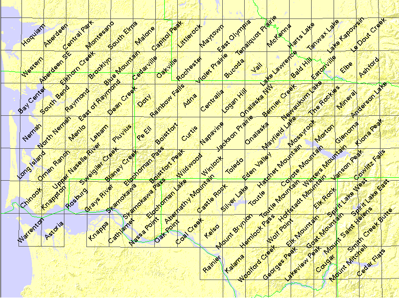
| USGS name | # quads | DNR# | name | file size |
|---|---|---|---|---|
| c46122a1 | 119 | - | (1°×2° quad) | 5383626 |
| f46122e1 | 32 | - | CENTRALIA (NE quarter) | 6382499 |
| f46123a1 | 23 | - | ASTORIA (SW quarter) | 5558216 |
| f46123e1 | 32 | - | CHEHALIS RIVER (NW quarter) | 5522916 |
| f45121h8 | 54 | - | MOUNT SAINT HELENS (SE quarter+) | 71071617 |
| z46122 | 64 | - | (Mosaicked 24K quads) | 176099896 |
| z46123 | 55 | - | (Mosaicked 24K quads) | 154927108 |
| o46123h8 | 1 | 1709 | Hoquiam | 3404887 |
| o46123h7 | 1 | 1710 | Aberdeen | 2445646 |
| o46123h6 | 1 | 1711 | Central Park | 2855334 |
| o46123h5 | 1 | 1712 | Montesano | 3206565 |
| o46123h4 | 1 | 1713 | South Elma | 3141203 |
| o46123h3 | 1 | 1714 | Malone | 2305079 |
| o46123h2 | 1 | 1715 | Capitol Peak | 2560603 |
| o46123h1 | 1 | 1716 | Little Rock | 2427449 |
| o46122h8 | 1 | 1717 | Maytown | 2166771 |
| o46122h7 | 1 | 1718 | East Olympia | 2276446 |
| o46122h6 | 1 | 1719 | Tenalquot Prairie | 1955808 |
| o46122h5 | 1 | 1720 | McKenna | 2016621 |
| o46122h4 | 1 | 1721 | Harts Lake | 1687809 |
| o46122h3 | 1 | 1722 | Tanwax Lake | 1957430 |
| o46122h2 | 1 | 1723 | Lake Kapowsin | 2603735 |
| o46122h1 | 1 | 1724 | Le Dout Creek | 2332601 |
| o46123g8 | 1 | 1809 | Western | 2018023 |
| o46123g7 | 1 | 1810 | Aberdeen SE | 2042805 |
| o46123g6 | 1 | 1811 | Elkhorn Creek | 2358369 |
| o46123g5 | 1 | 1812 | Brooklyn | 2720791 |
| o46123g4 | 1 | 1813 | Blue Mountain | 2629806 |
| o46123g3 | 1 | 1814 | Cedarville | 2593673 |
| o46123g2 | 1 | 1815 | Oakville | 2498573 |
| o46123g1 | 1 | 1816 | Rochester | 2177497 |
| o46122g8 | 1 | 1817 | Violet Prairie | 2184483 |
| o46122g7 | 1 | 1818 | Bucoda | 2661759 |
| o46122g6 | 1 | 1819 | Vail | 2497918 |
| o46122g5 | 1 | 1820 | Lake Lawrence | 2587569 |
| o46122g4 | 1 | 1821 | Bald Hill | 2665661 |
| o46122g3 | 1 | 1822 | Eatonville | 2932305 |
| o46122g2 | 1 | 1823 | Elbe | 2351512 |
| o46122g1 | 1 | 1824 | Ashford | 2681545 |
| o46123f8 | 1 | 1909 | Bay Center | 3917399 |
| o46123f7 | 1 | 1910 | South Bend | 2531023 |
| o46123f6 | 1 | 1911 | Raymond | 2723158 |
| o46123f5 | 1 | 1912 | East of Raymond | 2965347 |
| o46123f4 | 1 | 1913 | Dean Creek | 2281705 |
| o46123f3 | 1 | 1914 | Doty | 2669829 |
| o46123f2 | 1 | 1915 | Rainbow Falls | 2032805 |
| o46123f1 | 1 | 1916 | Adna | 2355001 |
| o46122f8 | 1 | 1917 | Centralia | 3049571 |
| o46122f7 | 1 | 1918 | Logan Hill | 2548544 |
| o46122f6 | 1 | 1919 | Onalaska NW | 2151739 |
| o46122f5 | 1 | 1920 | Bernier Creek | 2975928 |
| o46122f4 | 1 | 1921 | Newaukum Lake | 3698847 |
| o46122f3 | 1 | 1922 | The Rockies | 3800898 |
| o46122f2 | 1 | 1923 | Mineral | 3073185 |
| o46122f1 | 1 | 1924 | Anderson Lake | 2935729 |
| o46123e8 | 1 | 2009 | Nemah | 4023473 |
| o46123e7 | 1 | 2010 | North Nemah | 2039592 |
| o46123e6 | 1 | 2011 | Menlo | 3102334 |
| o46123e5 | 1 | 2012 | Lebam | 2478917 |
| o46123e4 | 1 | 2013 | Pluvius | 2440679 |
| o46123e3 | 1 | 2014 | Pe Ell | 2705773 |
| o46123e2 | 1 | 2015 | Boistfort | 2333388 |
| o46123e1 | 1 | 2016 | Curtis | 2229856 |
| o46122e8 | 1 | 2017 | Napavine | 1943743 |
| o46122e7 | 1 | 2018 | Jackson Prairie | 1744797 |
| o46122e6 | 1 | 2019 | Onalaska | 1932679 |
| o46122e5 | 1 | 2020 | Mayfield Lake | 2866583 |
| o46122e4 | 1 | 2021 | Mossyrock | 3291201 |
| o46122e3 | 1 | 2022 | Morton | 3377189 |
| o46122e2 | 1 | 2023 | Glenoma | 2949328 |
| o46122e1 | 1 | 2024 | Kiona Peak | 2902271 |
| o46123d8 | 1 | 2109 | Long Island | 3692442 |
| o46123d7 | 1 | 2110 | Oman Ranch | 2255659 |
| o46123d6 | 1 | 2111 | Upper Naselle River | 2010791 |
| o46123d5 | 1 | 2112 | Sweigiler Creek | 3393417 |
| o46123d4 | 1 | 2113 | Blaney Creek | 3255643 |
| o46123d3 | 1 | 2114 | Elochoman Pass | 3393983 |
| o46123d2 | 1 | 2115 | Boistfort Peak | 3242131 |
| o46123d1 | 1 | 2116 | Wildwood | 2634433 |
| o46122d8 | 1 | 2117 | Winlock | 2609707 |
| o46122d7 | 1 | 2118 | Toledo | 1964059 |
| o46122d6 | 1 | 2119 | Eden Valley | 2758254 |
| o46122d5 | 1 | 2120 | Hatchet Mountain | 2956981 |
| o46122d4 | 1 | 2121 | Coyote Mountain | 2333095 |
| o46122d3 | 1 | 2122 | Winters Mountain | 2665699 |
| o46122d2 | 1 | 2123 | Vanson Peak | 3439798 |
| o46122d1 | 1 | 2124 | Cowlitz Falls | 3140775 |
| o46123c8 | 1 | 2209 | Chinook | 3149545 |
| o46123c7 | 1 | 2210 | Knappton | 3261037 |
| o46123c6 | 1 | 2211 | Rosburg | 3361230 |
| o46123c5 | 1 | 2212 | Grays River | 2825306 |
| o46123c4 | 1 | 2213 | Skamokawa | 2903905 |
| o46123c3 | 1 | 2214 | Skamokawa Pass | 3058485 |
| o46123c2 | 1 | 2215 | Elochoman Lake | 2997880 |
| o46123c1 | 1 | 2216 | Abernathy Mountain | 2614094 |
| o46122c8 | 1 | 2217 | Castle Rock | 3374621 |
| o46122c7 | 1 | 2218 | Silver Lake | 2977710 |
| o46122c6 | 1 | 2219 | Toutle | 2665519 |
| o46122c5 | 1 | 2220 | Toutle Mountain | 2837620 |
| o46122c4 | 1 | 2221 | Hoffstadt Mountain | 2883461 |
| o46122c3 | 1 | 2222 | Elk Rock | 3494719 |
| o46122c2 | 1 | 2223 | Spirit Lake West | 3078769 |
| o46122c1 | 1 | 2224 | Spirit Lake East | 3511055 |
| o46123b8 | 1 | 2309 | Warrenton | 4544319 |
| o46123b7 | 1 | 2310 | Astoria | 4041790 |
| o46123b5 | 1 | 2312 | Knappa | 2798260 |
| o46123b4 | 1 | 2313 | Cathlamet | 3417977 |
| o46123b3 | 1 | 2314 | Nassa Point | 2704277 |
| o46123b2 | 1 | 2315 | Oak Point | 3229693 |
| o46123b1 | 1 | 2316 | Coal Creek | 3265823 |
| o46122b8 | 1 | 2317 | Kelso | 3877590 |
| o46122b7 | 1 | 2318 | Mount Brynion | 2640836 |
| o46122b6 | 1 | 2319 | Hemlock Pass | 2532327 |
| o46122b5 | 1 | 2320 | Wolf Point | 2731692 |
| o46122b4 | 1 | 2321 | Elk Mountain | 3174191 |
| o46122b3 | 1 | 2322 | Goat Mountain | 3204395 |
| o46122b2 | 1 | 2323 | Mount Sainte Helens | 3019952 |
| o46122b1 | 1 | 2324 | Smith Creek Butte | 3249893 |
| o46122a8 | 1 | 2417 | Rainier | 3197576 |
| o46122a7 | 1 | 2418 | Kalama | 3092235 |
| o46122a6 | 1 | 2419 | Woolford Creek | 2878499 |
| o46122a5 | 1 | 2420 | Georges Peak | 2919335 |
| o46122a4 | 1 | 2421 | Lakeview Peak | 3146663 |
| o46122a3 | 1 | 2422 | Cougar | 2788103 |
| o46122a2 | 1 | 2423 | Mount Mitchell | 3292853 |
| o46122a1 | 1 | 2424 | Cedar Flats | 3223681 |